Soví hrad
Šurice Banská Bystrica county Slovakia
extinct castle
Soví hrad
Šurice Banskobystrický kraj Slovakia
zaniknutý hrad
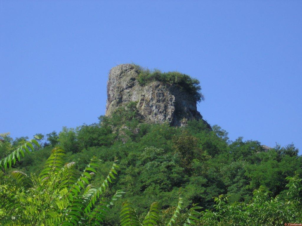
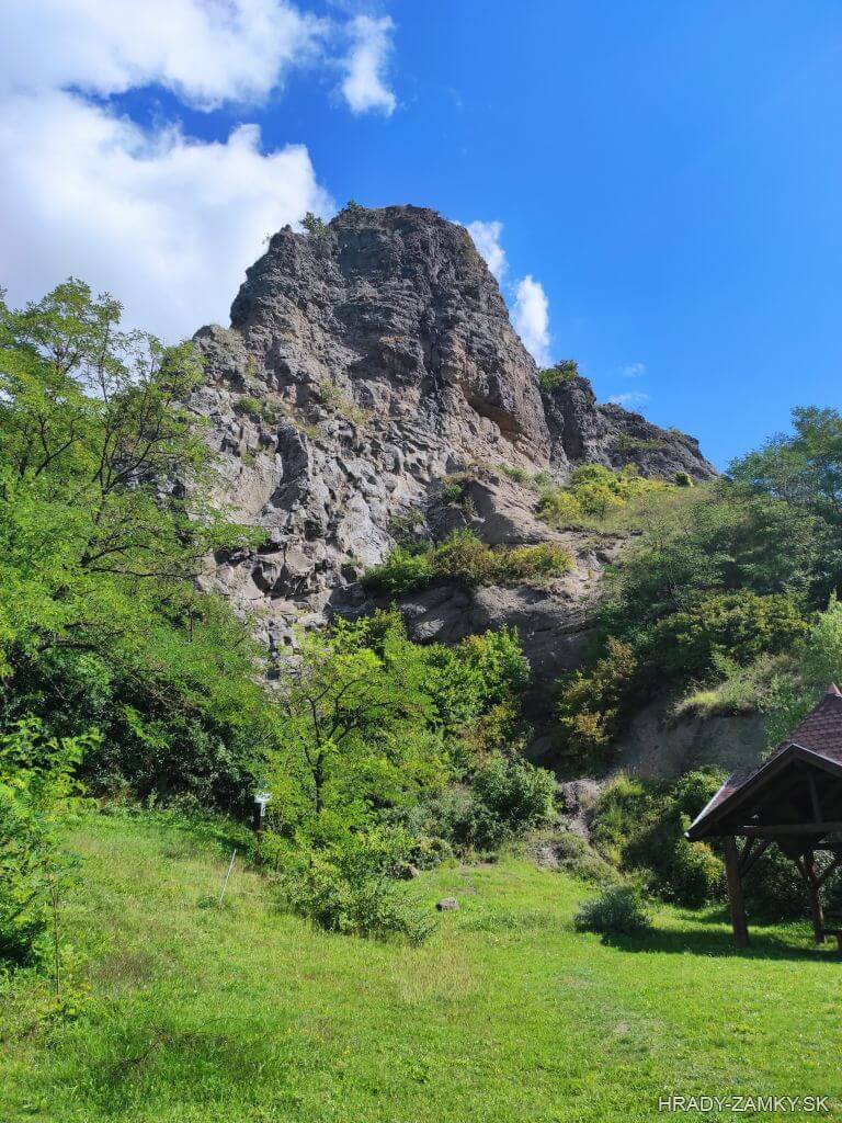
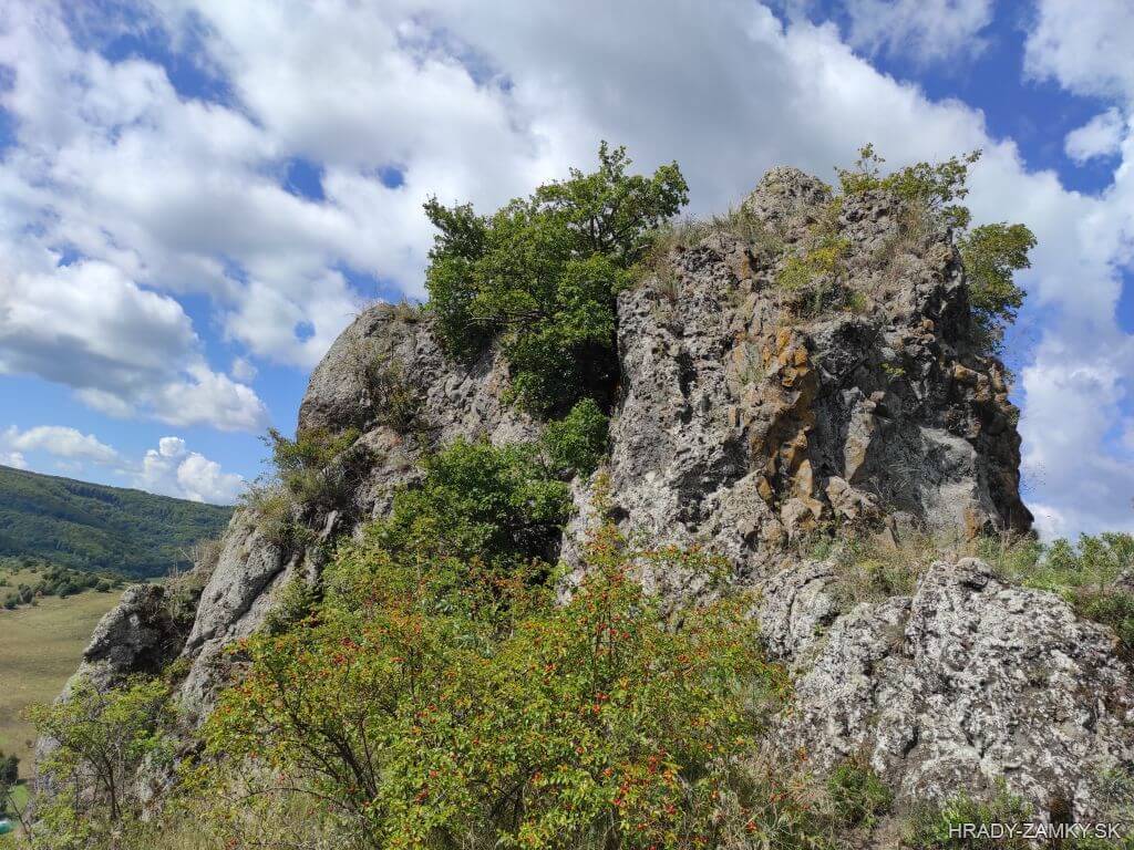
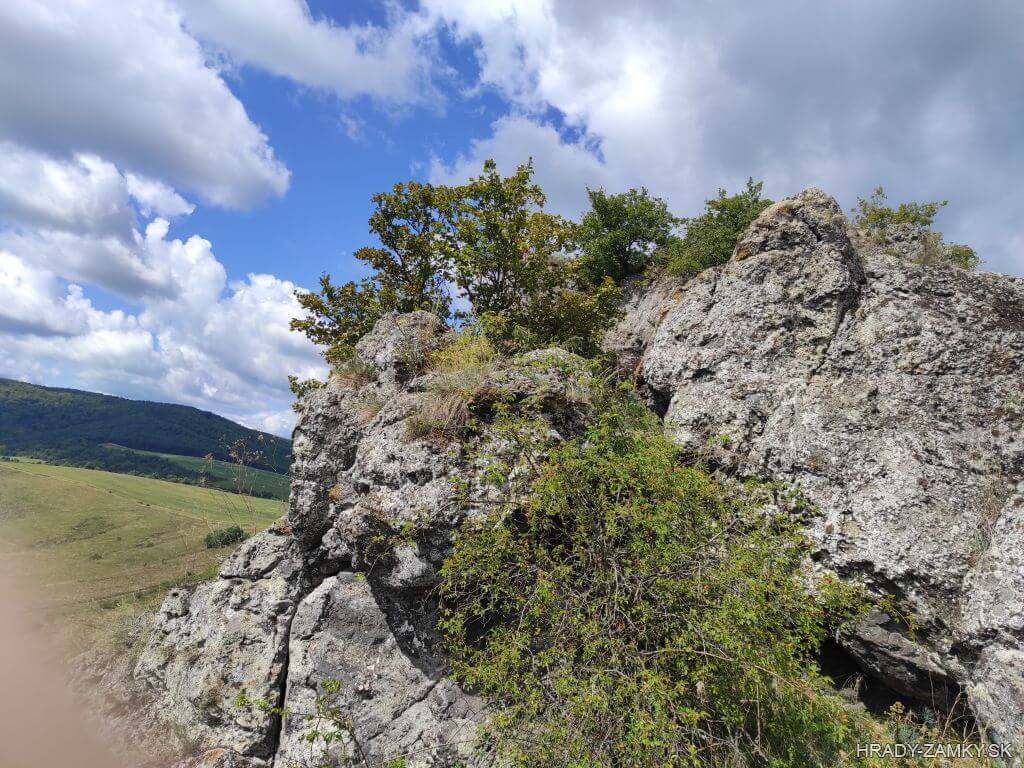
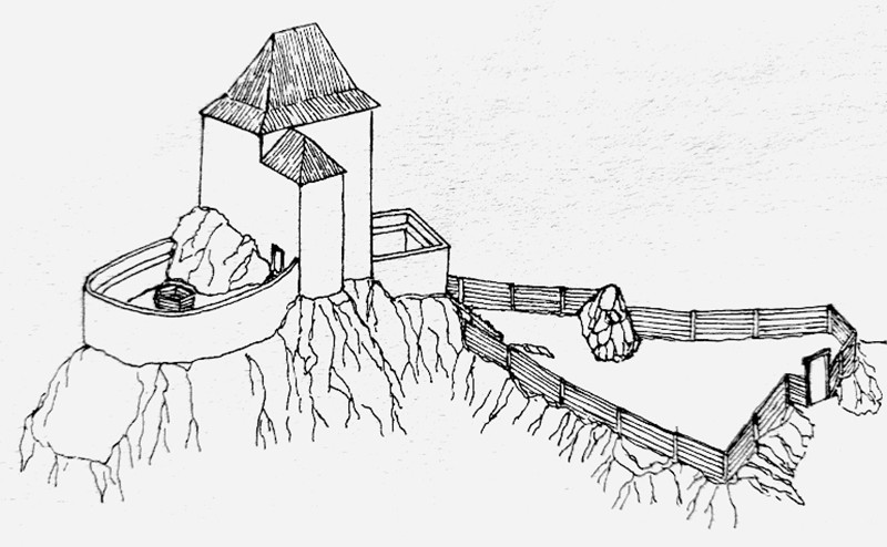
A very rare rock formation, on which stood the already extinct castle, in the cadastral area of the village of Šurice in the district of Lučenec
Veľmi vzácny skalný útvar, na ktorom stál dnes už zaniknutý hrádok, v katastrálnom území obce Šurice v okrese Lučenec
Previous names
Šurický hrad, Danošov kameň, Dánoskő, Darmskő, Sőreg - Bagolyvár
Roads
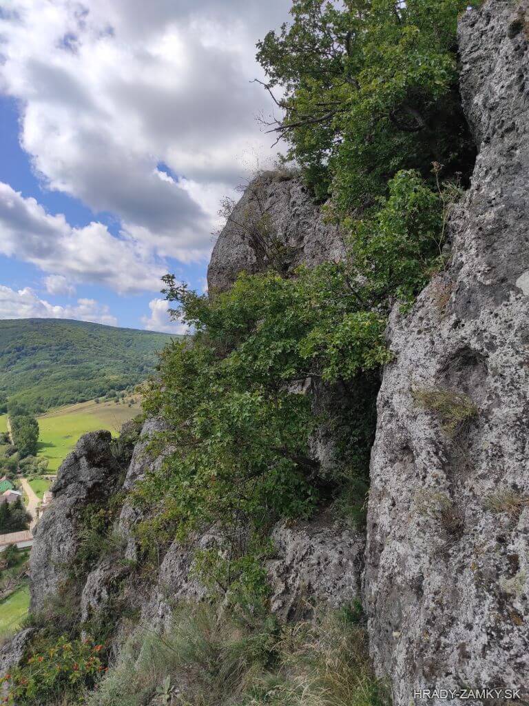
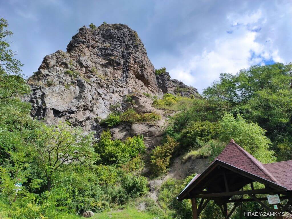
The village of Šurice is located southeast of Fiľakovo, near the castle Hajnáčka. After entering the village we come to a crossroads, where the road divides into two branches. We continue straight on along the right branch further through the village and at the first possible turn to the left we come directly to the location of Soví Hrad. There is a grassy area with a tourist shelter and an information board where we can park. From there we continue on foot to the left on the path through the forest, which leads around the rock cliff and then we go out into the open meadow. From there only a few meters to the right and we are right at the cliff. There is a cistern carved into the rock at the very top, but we do not recommend ordinary tourists to climb the rock.
Obec Šurice sa nachádza juhovýchodne od Fiľakova, blízko hradu Hajnáčka. Po vstupe do obce prídeme ku križovatke, kde sa cesta rozdeľuje na dve vetvy. Pokračujeme stále rovno tou pravou vetvou ďalej cez obec a pri prvej možnej odbočke vľavo prídeme priamo k lokalite Sovieho hradu. Je tu trávnatá plocha s turistickým prístreškom a infotabuľou, kde môžeme zaparkovať. Odtiaľ pokračujeme peši trasou vľavo cez les, ktorou obídeme skalné bralo a vyjdeme na otvorenú plochu. Odtiaľ už len pár metrov vpravo a sme priamo pri brale. Úplne na vrchole je do skaly vytesaná cisterna, avšak bežným turistom neodporúčame na skalu liezť.
Description
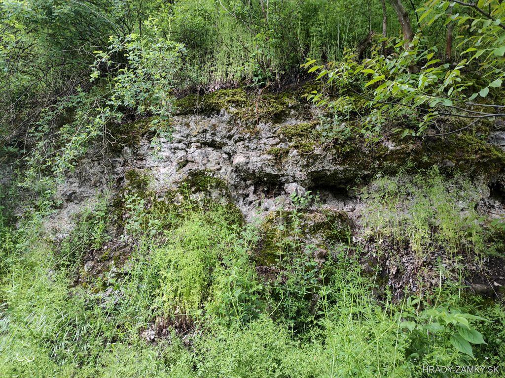
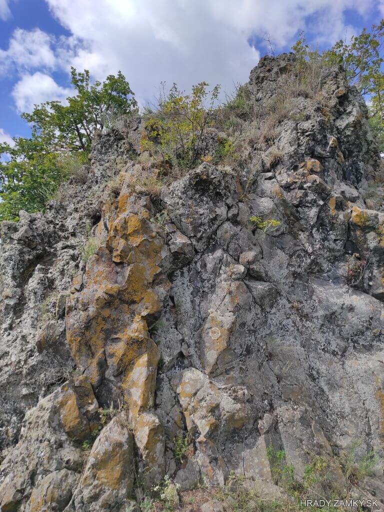
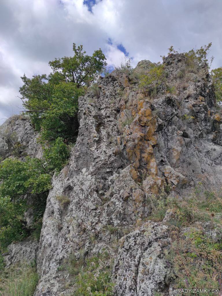
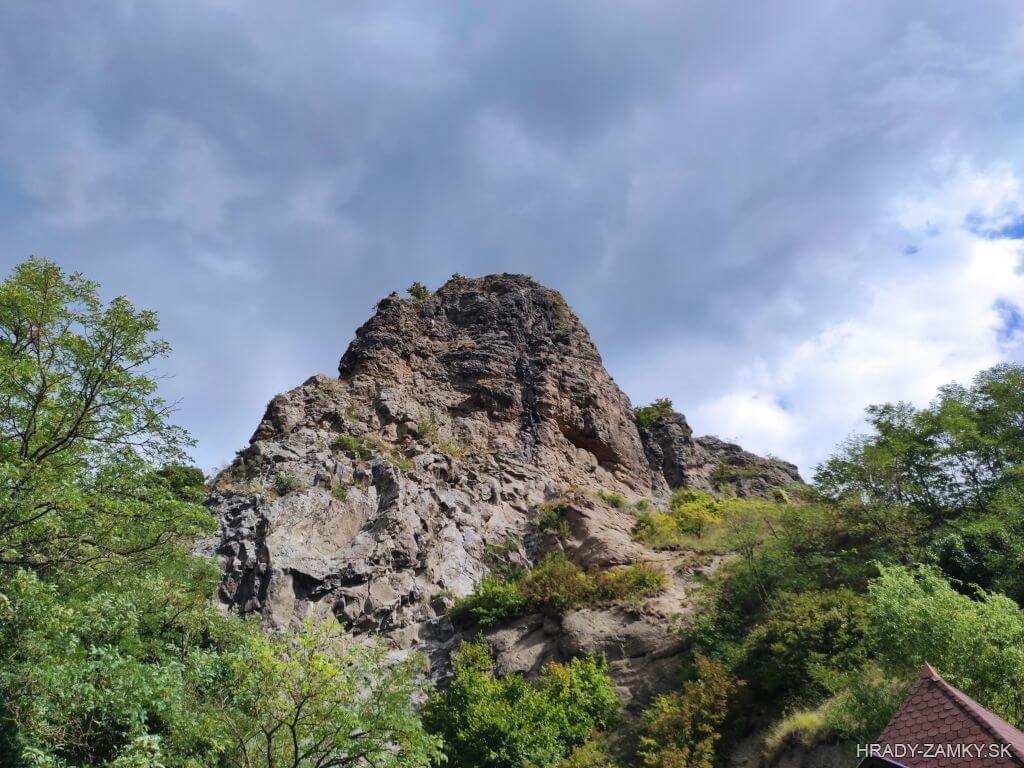
The rock, on which the castle was located, was created as a filling of the volcanic chimney at the beginning of the Quaternary and determined the shape and floor plan of the castle. At the highest point of the cliff are traces of the foundations of a probably residential tower with a floor plan of an irregular trapezoid. One level lower, on the west side, there is a large cistern carved into the rock on the rock plateau. On the south side there is a jammed small platform through which the building with the cistern could be entered and on the east side there is about 9 m lower another platform with a bedrock, where there could have been very small farm buildings between the rocks. This area could later be extended further east, where there were probably other farm and defense facilities. However, apart from three jammed stairs at the edge of the area, no traces of them have been preserved.The highest part of the castle was probably accessible only by a ladder, which kept the upper castle and cistern well protected. In the vicinity of the former tower there are traces of the location of the walls and their disposition indicates a small yard with an entrance to the wall, or a small guardhouse. In the western part, about 5 m lower, the mentioned cistern begins with a traces of a roof or a water collection device. The medieval origin of the locality was also confirmed by a research by M. Matejka and P. Gutek, as well as by the results of a smaller research by Z. Drenka in 1962.
Bralo, na ktorom sa hrádok nachádzal, sa vytvorilo ako výplň sopečného komína začiatkom štvrtohôr a určilo tvar i pôdorys hrádku. Na najvyššom mieste brala sú stopy po základoch pravdepodobne obytnej veže s pôdorysom nepravidelného lichobežníka. O úroveň nižšie, zo západnej strany, je na skalnej plošine veľká, do skaly vytesaná cisterna. Na južnej strane je zasekaná malá plošina, ktorou sa mohlo do objektu s cisternou vchádzať a na východnej strane je cca o 9 m nižšie ďalšia plošina so skalným podložím, kde mohli byť medzi skalami veľmi malé hospodárske stavby. Táto oblasť mohla byť neskôr rozšírená ďalej na východ, kde zrejme stáli ďalšie hospodárske ale aj obranné objekty. Okrem troch zasekaných schodov na okraji plochy sa po nich však žiadne stopy nezachovali.Najvyššia časť hradu bola pravdepodobne prístupná len rebríkom, čím boli horný hrad a cisterna dobre chránené. V okolí niekdajšej veže sú stopy po lôžkach múrov a ich dispozícia naznačuje malý dvor so vstupom v múre, alebo malú strážnicu. V západnej čast zhruba o 5 m nižšie začína spomínaná cisterna so zreteľnými kapsami pre trámy - strecha, alebo naberacie zariadenie vody. Stredoveký pôvod lokality potvrdilo aj zameranie lokality M.Matejkom a P.Gutekom, tiež aj výsledky menšieho prieskumu Z.Drenku v roku 1962.
Plan
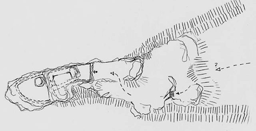
Legend to the ground plan
- Source: Peter Gutek
- 2002
Legenda k pôdorysu
- Zdroj: Peter Gutek
- 2002
History
Not much information has been preserved about the history of the castle, on the site of a natural rock formation called Soví hrad - Owl Castle. The rock itself formed as a volcanic chimney filling in the last phase of volcanic activity at the beginning of the Quaternary. At the top of the hill there are clear traces of the castle, whose medieval origin was confirmed by a smaller archaeological research.
Many sources mention the village of Šurice in connection with the servants of Beckov castle, later the castle soldiers, who inhabited it and probably built a fortress on the site of Hajnáčka, so it is possible that before the Tatar invasion in Hajnáčka there was a small fortress, as Hajnáčka Castle itself is mentioned later.
In the document of Belo IV. from 1245 it is mentioned that Budik's son Tivadar, Ompud's son Visobur and Farkaš's son Dema, servants of Beckov Castle from the village of Šurice, fortified the Dánoskő hill at their own expense at the time of the Tatar invasion. Therefore, the king freed them from the rights of Beckov Castle and gave the mentioned castle to them and their descendants in the hereditary property on condition that they commit themselves to services in the royal army.
Most likely, the Dánoskő Castle, now known as the Owl Castle, mentioned in the document, was built by the same servants as a defense against the Tatars on an 85-meter-high rock. At first, it was just a hastily built fortification, which used the rock cliffs for its defensive benefit and withstood the attack of the Tatars.
In the end of the 13th century the cavalry master Kakas of the Rátót family, the ancestor of the Kakas family in Kaza, has rebuilt the fortifications into a castle. The castle is first mentioned in 1341, when it belonged to Kakas' son Ján and then to his sons Ladislav and Ján. The castle is still mentioned as their property in 1372 and 1375. In 1385, when Queen Mary donated properties to Ladislav, the castle is no longer mentioned and in the document of King Sigismund from 1415 it is mentioned as a ruin.
Count Eugen Nyáry made excavations on the castle hill in 1870, from where he managed to collect fragments of pottery and many other objects. The findings prove that this place once played a strategically important role and was inhabited as early as the Stone Age.
The medieval origin of the locality was confirmed by the focus of M. Matejka and P. Gutek, as well as the results of a smaller survey of Z. Drenka in 1962.
The upper castle and the still visible cistern carved into the rock were located on the highest plateau of the rock. This part is accessible only by climbing almost 10m of rock, it is strongly not recommended for inexperienced climbers. In the vicinity of the former tower there are traces of wall beds and their disposition indicates a small courtyard with an entrance in the wall, or a small guardhouse.
O histórii hradu, na mieste prírodného skalného útvaru označovaného ako Soví hrad, sa nezachovalo veľa informácií. Samotné bralo sa vytvorilo ako výplň sopečného komína v poslednej fáze vulkanickej činnosti začiatkom štvrtohôr. Na vrchole brala sú zreteľné stopy po hrade, ktorého stredoveký pôvod bol potvrdený menším archeologickým prieskumom.
Mnohé zdroje spomínajú obec Šurice v súvislosti s jobagiónmi z Beckova, neskôr hradnými vojakmi, ktorí ju obývali a zrejme postavili pevnosť na mieste Hajnáčky, preto je možné, že už pred tatárskym vpádom na Hajnáčke stála malá pevnosť, keďže samotný hrad Hajnáčka sa spomína až neskôr.
V listine Bela IV. z roku 1245 sa spomína, že Budikov syn Tivadar, Ompudov syn Visobur a Farkašov syn Dema, poddaní Beckovského hradu z dediny Šurice, v čase vpádu Tatárov na vlastné náklady opevnili vrch Dánoskő. Preto ich kráľ oslobodil od právomocí Beckovského hradu a spomínaný hrad im a ich potomkom dal do dedičného vlastníctva pod podmienkou, že sa zaviažu k službám v kráľovskom vojsku.
S najväčšou pravdepodobnosťou teda v listine spomínaný hrad Dánoskő (Darmskő), dnes zvaný ako Soví hrad, postavili tí istý jobagióni ako obranu proti Tatárom na 85 metrov vysokej skale. Spočiatku sa jednalo len o narýchlo postavené opevnenie, ktoré využívalo vo svoj obranný prospech skalné bralo a odolalo náporu Tatárov.
Až na konci 13. storočia, jazdecký majster Kakas z rodu Rátót, predok rodu Kakasovcov v Kaze, dal opevnenie prestavať na hrad. Prvýkrát sa hrad spomína v roku 1341, keď patril Kakasovmu synovi Jánovi a potom jeho synom Ladislavovi a Jánovi. Ako ich majetok sa hrad spomína ešte aj v rokoch 1372 a 1375. V roku 1385, keď kráľovná Mária darovala Ladislavovi majetky, sa hrad už nespomína a v listine kráľa Žigmunda z roku 1415 sa uvádza ako zrúcanina.
Gróf Eugen Nyáry uskutočnil v roku 1870 vykopávky na hradnom kopci, odkiaľ sa mu podarilo zozbierať úlomky keramiky a mnohé ďalšie predmety. Nálezy dokazujú, že toto miesto malo kedysi strategicky významnú úlohu a bolo osídlené už v dobe kamennej.
Stredoveký pôvod lokality zas potvrdilo zameranie M.Matejkom a P.Gutekom, tiež aj výsledky menšieho prieskumu Z.Drenku v roku 1962.
Na najvyššej plošine brala sa nachádzal horný hrad a dodnes viditeľná cisterna vytesaná do skaly. Táto časť je prístupná len zdolaním takmer 10m skaly, dôrazne sa neodporúča neskúseným lezcom. V okolí niekdajšej veže sú stopy po lôžkach múrov a ich dispozícia naznačuje malý dvor so vstupom v múre, alebo malú strážnicu.
Myths and legends
There are no myths available.
K tomuto objektu nie sú dostupné žiadne povesti
Useful information
The site is freely accessible
Lokalita je voľne prístupná
Nearby castles