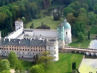
Castle Węgierka
Powiat jarosławski Podkarpackie Poland
castle, chateau
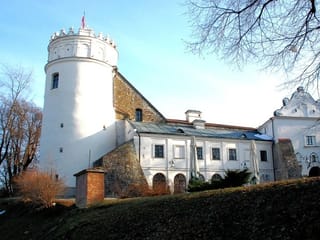
Baszta Węgierka
Powiat jarosławski Podkarpackie Poland
castle, chateau
The owners of the Węgierka castle (initially known as Tuliczów) originally inhabited a fortified manor erected in 1484 by Piotr Rozborski
Ruiny bastejowego zamku posadowione są w dolinie, w północnej części wsi
Previous names
Castle Węgierka, Башта Венгерка, Baszta Węgierka, Башня Венгерка
Description
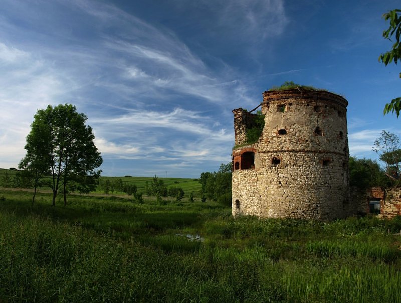
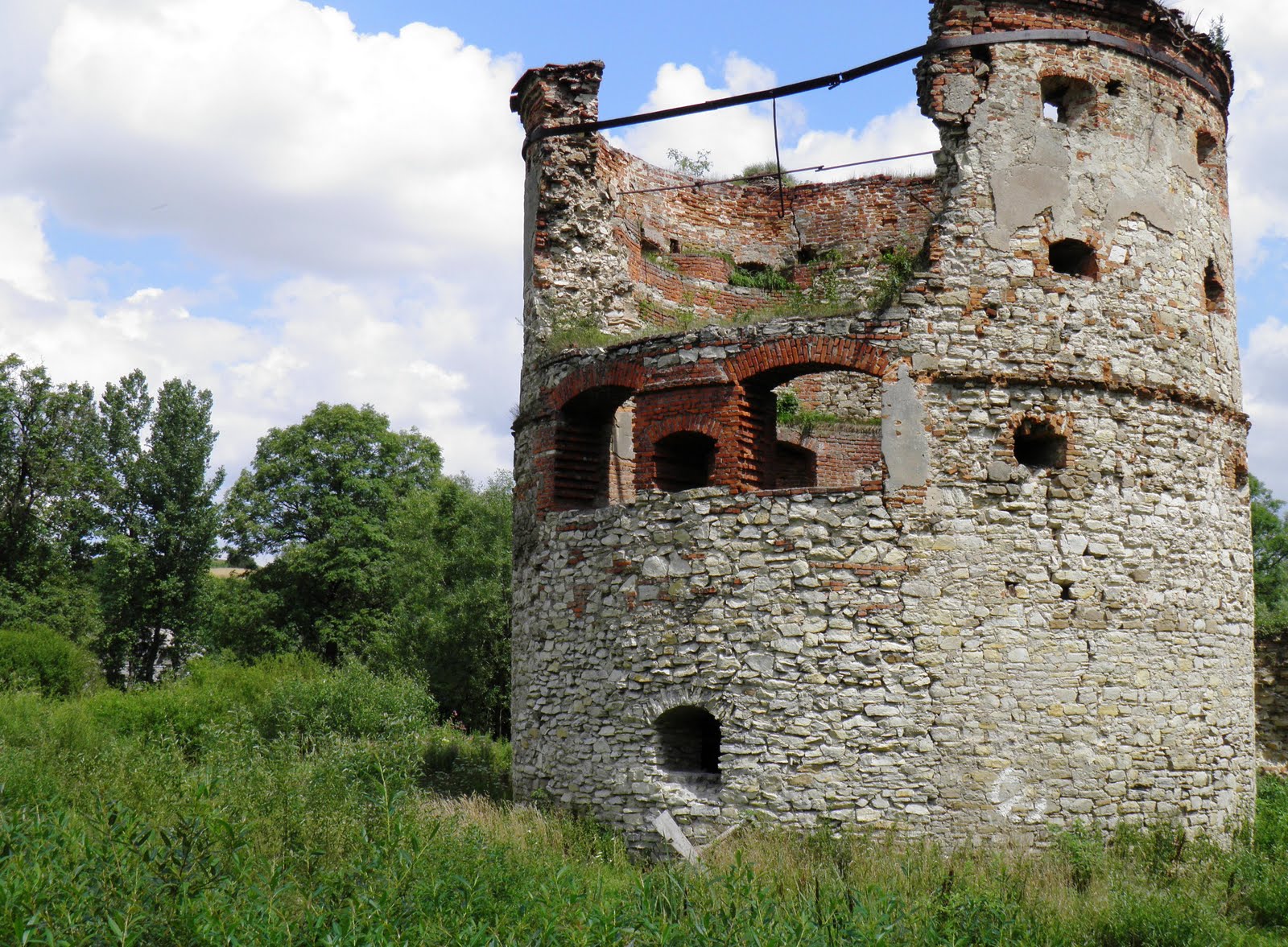
The owners of the Węgierka castle (initially known as Tuliczów) originally inhabited a fortified manor erected in 1484 by Piotr Rozborski. The castle complex was build during the fourth quarter of the 16th century, for the funds provided by Jan Pieniążek. The castle was built according to a “tower-and-roundel” design, on a quadrilateral plan (40 x 40 metres), with a courtyard in the centre of the complex. Cylindrical brick and stone roundels were positioned on the corners of the fortified structure. It is known that during the 17th and the 18th century, the castle was surrounded from all sides by a moat filled with water, which, along with the nearby reservoirs, formed a significant part of the defence system of the castle. The Pieniążek family owned the castle until 1712, later to be succeeded by the Siemianowski family, Józef Rosnowski and - from 1731 onwards - by Józef Morski, the cup-bearer (cześnik) of Przemyśl. Following his death in 1739, his property - along with the Węgierka castle - was inherited by his son, Antoni Morski, who would later become the castellan of Lviv; the transfer of property was confirmed by the division of assets performed in 1744. After the death of Antoni Morski in 1776, the manor and the castle was inherited by Tadeusz Morski, his son, who remained the owner thereof until 1808. The north-western roundel, which survives to this day, was built on a circular floor plan with a diameter of 12 metres and had four storeys with embrasures in its walls as well as a conical roof. During the second half of the 19th century, the most dilapidated sections of the castle were demolished; from that point onwards, the castle stood abandoned and began to crumble. The south wing of the castle was finally demolished in 1929. Apart from the north-western roundel, parts of the western wing of the castle which used to serve as living quarters have also survived.
The castle is located by the river Mleczka, on the western side of the road leading from Helusz to Pruchnik, on marshy lowlands; the castle is surrounded by a moat and a pond. The remaining parts of the castle are the ruins of a brick and stone north-western fortified tower, built on a circular floor plan, as well as the western wing which used to perform residential functions. The castle consists of a cylindrical fortified tower with basement, featuring four storeys, connected to a the cuboid fragment of the western wing of the former fortified manor. The surviving tower, built from split stones and brick, comes equipped with embrasures designed to protect the defending riflemen against enemy fire. The lower section of the tower remains flooded with water. The tower is in a state of progressing decay resulting from its exposure to the elements which causes the walls to crack. This process was delayed using a temporary metal brace installed on the northern side of the tower on the upper storey level. A surviving fragment of a stone curtain wall abuts the fortified tower from the east. A single-storey brick residential building erected in 1929 stands on the spot where the former western wing once stood, abutting the now-defunct south-western tower. The surviving parts of the castle contain no fixtures or fittings whatsoever.
Ruiny bastejowego zamku posadowione są w dolinie, w północnej części wsi. Do naszych czasów z obronnej rezydencji zachowała się jedynie cylindryczna wieża ze strzelnicami oraz dwa budynku stojący przy dziedzińcu. W 1978-1979 roku zamek został wstępnie przebadany metodą wykopaliskową przez S. Lewandowskiego. Później przeprowadzono rozpoznanie geofizyczne. Pierwsze wzmianki dotyczące miejscowego majątku pochodzą z XIV wieku kiedy to należał do dziedzica Jacka Słoneczko a po nim Macieja Mzurowskiego. Zamek ufundowany została przez kolejnych właścicieli majątku ? Pruchnickich herbu Korczak albo Rozborskich. Zachował się przekaz źródłowy z 1484 roku, dotyczący pożyczki 200 florenów zaciągniętej na budowę dworu przez Piotra Rozborskiego. Już w 1505 roku majątek wrócił do Pruchnickich a potem należał do Pieniążków inicjatorów przebudowy zachowanej formy zamku. Utrzymywali się oni w posiadaniu warowni aż do początku XVIII wieku. Pod koniec tego wieku warownia została strawiona przez pożar i nie została już odbudowana.
Założenie miało formę czworoboku z narożnymi bastejami. Zachowana do dziś czterokondygnacyjna baszta północno-zachodnia ze strzelnicami kluczowymi wzniesiona została na planie koła o średnicy 13,2 m z kamieni i cegieł. Podobna baszta wznosiła się w narożniku południowo-zachodnim. Pozostałe dwie baszty dotychczas nie zostały zlokalizowane. Natrafiono na fragmenty murów pomieszczeń mieszkalnych w skrzydle południowym. Skrzydło wschodnie nie zostało zlokalizowane. Zachowane skrzydło zachodnie posadowione zostało na planie prostokąta o wymiarach 10,1 X 44 m. Ruiny nie konserwowane wołają o pilne prace zabezpieczające mogące powstrzymać ich postępującą destrukcję. Zabytek wymaga również dalszych prac badawczych.
Nearby castles