Pevensey Castle
East Sussex England England
castle, chateau
Pevensey Castle is a medieval castle and former Roman Saxon Shore fort at Pevensey in the English county of East Sussex
Previous names
Pevensey Castle
Description
Pevensey Castle is a medieval castle and former Roman Saxon Shore fort at Pevensey in the English county of East Sussex. The site is a Scheduled Monument in the care of English Heritage and is open to visitors. Built around 290 AD and known to the Romans as Anderitum, the fort appears to have been the base for a fleet called the Classis Anderidaensis. The reasons for its construction are unclear; long thought to have been part of a Roman defensive system to guard the British and Gallic coasts against Saxon pirates, it has more recently been suggested that Anderitum and the other Saxon Shore forts were built by a usurper in an ultimately unsuccessful attempt to prevent Rome from reimposing its control over Britain.
Anderitum fell into ruin following the end of the Roman occupation but was reoccupied in 1066 by the Normans, for whom it became a key strategic bulwark. A stone keep and fortification was built within the Roman walls and faced several sieges. Although its garrison was twice starved into surrender, it was never successfully stormed. The castle was occupied more or less continuously until the 16th century, apart from a possible break in the early 13th century when it was slighted. It had been abandoned again by the late 16th century and remained a crumbling, partly overgrown ruin until it was acquired by the state in 1925.
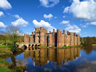
Pevensey Castle was reoccupied between 1940 and 1945, during the Second World War, when it was garrisoned by units from the Home Guard, the British and Canadian armies and the United States Army Air Corps. Machine-gun posts were built into the Roman and medieval walls to control the flat land around Pevensey and guard against the threat of a German invasion. They were left in place after the war and can still be seen today. Pevensey is one of many Norman castles built around the south of England.
Location and dimensions
Pevensey Castle was constructed by the Romans on a spur of sand and clay that stands about 10 metres (33 ft) above sea level. In Roman times this spur was a peninsula that projected into a tidal lagoon and marshes, making it a strong natural defensive position. A harbour is thought to have been situated near the south wall of the castle, sheltered by a long spit of shingle where the village of Pevensey Bay stands now. A small river, Pevensey Haven, runs along the north side of the peninsula and would originally have discharged into the lagoon, but is now largely silted up.
Since Roman times, silting and land reclamation in the Pevensey Levels have pushed the coastline out by about 1.5 kilometres (0.9 mi), leaving the castle landlocked. The land between the castle and the sea is now a flat marshland drained by a network of ditches and sewers or field drains. The modern village of Pevensey is situated mostly to the east of the castle, at the end of the ancient peninsula. Castle Road (the B2191) curves around the Roman north wall and connects Pevensey to the nearby village of Westham. A public footpath crosses the interior of the castle, linking the two villages.An area of reclaimed land, formerly part of the Pevensey tidal lagoon but now marshland and fields crossed by the Eastbourne to Hastings railway line, is situated immediately to the south of the castle.
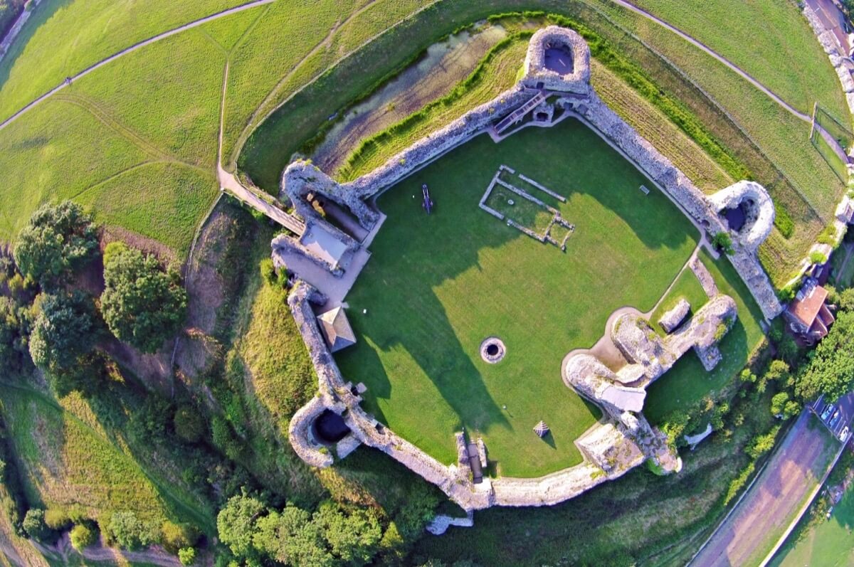
The castle occupies an area of about 3.67 hectares (9.1 acres). It has an oval plan on a north-east/south-west alignment, measuring 290 metres (950 ft) by 170 metres (560 ft). Not only is it the largest of the nine Saxon Shore forts[6] but its walls and towers are the largest of any surviving Roman fort of the period.Its shape is unique among Saxon Shore forts and was presumably determined by the contours of the peninsula on which it stands.
Architecture
Curtain wall and towers
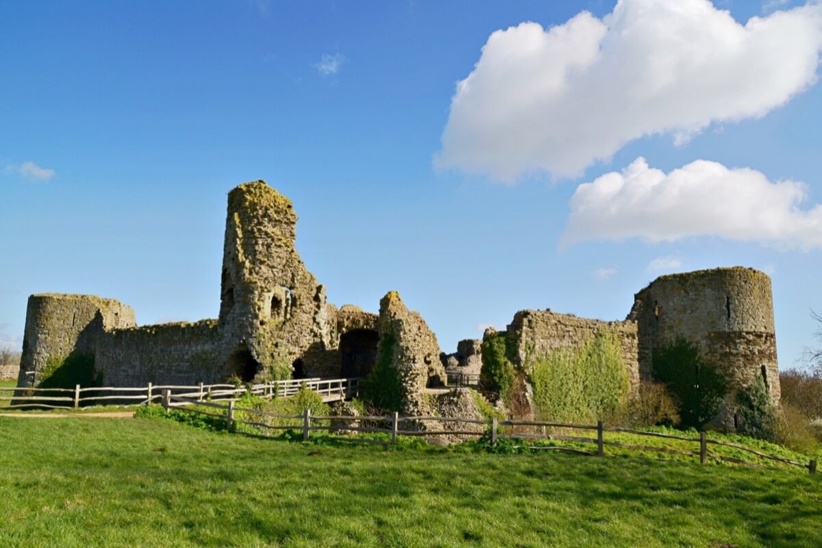
The castle's curtain wall is built on a massive scale, with ramparts and projecting towers still standing up to 8.2 metres (27 ft) high (and probably about 9.5 metres (31 ft) high when built) and 4.2 metres (14 ft) thick at the base. The north, east and west sections of the curtain wall have survived mostly intact, with the exception of one fallen segment of the north wall; the south wall, which would have adjoined sea or marsh, has almost entirely disappeared.It is faced with ironstone and sandstone, though most of the original facing stones have been robbed out over the centuries; the structure visible now consists mostly of the rubble and sandstone core, bound together with mortar. Bonding courses of tiles run horizontally through the wall.An impression of its original appearance can be gleaned from an area in the north wall which has been excavated down to the still-intact foundations, revealing how it was once faced on both sides with small blocks of stone. The wall originally had a stepped appearance with at least two levels of steps on the interior face, though there is no surviving indication of how the garrison reached the top. At the top of the wall the remains of medieval crenellations can still be seen, which probably replaced Roman originals.
The D-shaped towers along the curtain wall are similar to those of several other Saxon Shore forts, although their placement is somewhat unusual. Because the fort was partly surrounded by marshes and water, which provided natural defences, the Romans economised by only building towers on the more vulnerable north-eastern and far western sectors. The towers were probably used to mount artillery weapons such as catapults and heavy crossbows. Ten towers still survive, though there may originally have been more before the loss of the south wall.
Gates
The Roman fort had two principal entrances, one on the east side and the other on the west, guarded by clusters of towers. The west gate covered the landward access via the causeway that linked Pevensey to the mainland. A ditch bisected the causeway, which led up to a rectangular gatehouse with a single arch around 2.4 metres (7 ft 10 in) wide, with a D-shaped tower on each end from which archers could fire along the archway. The main entrance of the Saxon Shore fort at Portchester, built around the same period, had a very similar plan. Nothing now remains of the Roman gatehouse, which was replaced during medieval times, while only a few stones are left of the medieval gatehouse.
The east gate, 2.8 metres (9 ft 2 in) wide, still stands; although what is visible now is principally medieval and 19th century, the Roman original probably did not look much different. A postern gate was set into the north wall next to a section that has now collapsed. It was originally constructed in the form of a narrow curved passageway. Another postern gate may have been set into the collapsed south wall. These suggest that there may have been routes into the fort from across the marshes or access from a harbour, of which no trace remains.
Interior
The interior of the fort was artificially raised by the Romans, using earth dug from the foundation ditch, to bring it up to the level of the projecting step on the back of the wall. No evidence of significant buildings within the fort has been found by excavators. A number of Roman hearths are situated at regular intervals in the centre of the fort's interior, suggesting that they may have been the site of wooden barrack blocks. The buildings are conjectured to have been largely timber-framed wattle and daub structures which have left little trace.
Inner bailey
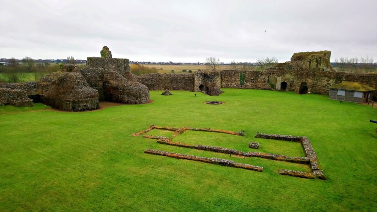
The Normans divided the interior of the old Roman fort into two fortified enclosures, referred to as the inner and outer baileys. The inner bailey of the castle was, in effect, a castle within a castle, consisting of a walled fortification with a tower at each corner, surrounded by a moat and with a keep of unusual design at its eastern extremity, adjoining the old Roman curtain wall. The present stone fortifications of the inner bailey date mainly from the 13th and 14th centuries. They replaced the original wood and earth fortifications of the Norman inner bailey, which occupied a much larger area of the Roman fort's interior. Traces of the Norman bailey's ditch and earthen rampart, which stretched right across the interior of the fort, can still be seen today. The inner bailey protected the castle's most important domestic buildings, while the outer bailey was used for buildings of lesser importance such as a granary for the manor of Pevensey.
The inner bailey's moat – which is fed by a spring – was probably over 18 metres (59 ft) wide when first dug. The moat protected a mid-13th century curtain wall, which is still largely intact, that divides the inner and outer baileys. A wooden bridge around 20.7 metres (68 ft) long linked the inner and outer baileys, though the cost of maintaining it prompted its replacement in 1405 with a stone causeway and drawbridge pit that can still be seen today. The principal entrance to the inner bailey was through the early 13th century gatehouse at the end of the entrance bridge, which had two D-shaped towers flanking a vaulted entrance passage. The towers were built on three levels with arrow slits in each level and basements below, which have survived intact. One of the basements can be reached via a spiral staircase; the other can only be accessed through a hole in the tower's floor and may have been used as a prison cell or oubliette. The gatehouse towers were built with open backs, which were probably closed by a wooden wall.
Three other towers still stand on the east, north and south sides of the inner bailey's curtain wall. Built in the mid-13th century, they each had three floors which were accessed through separate entrances on each level. Lighting was provided by arrow-slits, and the upper room in each tower, which was the only one to have a fireplace, was probably used as a lodging area. A latrine was also provided. Only the north tower is known to have been completed; however, its vaulted basement was mostly destroyed around 1317 when the roof and floors of the tower collapsed into it. It is not clear whether the south and east towers were ever completed. An estimate written in 1317 reveals that the towers were thatched, lacking castellations and a proper lead roof, but it is not known whether the work itemised in the estimate was ever carried out. The interiors of the towers were substantially modified in 1940.
The interior of the inner bailey is now a broad, grassy area dominated by the stump of the keep at its eastern edge, which survives only up to its first floor. Despite the massive nature of the ruins, they preserve little of the original design apart from its unique ground plan. It consisted of a rectangular block measuring about 16.8 metres (55 ft) by 9 metres (30 ft) internally with seven projecting towers, a design found in no other medieval castle. Nothing remains of the interior and the uniqueness of its design makes it difficult to reconstruct its internal layout. Surviving 14th century documents record that it contained a kitchen and a chapel, and had an iron door at its main entrance which was approached up a wooden stair.Like most Norman keeps, the entrance was situated on the first floor; the ground floor lacks any openings and it appears to have been constructed as a solid mass of masonry filled with clay. The near-total destruction of everything above the first floor means that the keep's original height is unknown, but it may have stood to a height of about 25 metres (82 ft) or so.
The keep underwent at least two redesigns in the first half of the 14th century, possibly prompted by damage inflicted in earlier sieges. One of the redesigns involved constructing an adjoining square tower which some have suggested could have been used to mount a catapult; large stone balls, used as catapult ammunition, can still be seen in the inner bailey today. The building was recorded to be dilapidated for much of the 14th century despite repeated repairs, and had fallen into ruin by the 16th century. It was subjected to systematic stone-robbing for centuries; as early as 1591, it was recorded that all the best stones had been "imbeselled and carried away" and that one family had removed no fewer than 677 cartloads of ashlar facing-stone from the keep's walls. A late 18th century engraving shows the remains of the building in a state of collapse and it had completely collapsed by the 1880s.The ruins were largely buried under a great heap of earth and clay that had been deposited sometime in the late medieval or early modern periods, which was not removed until the 1920s. The reason for the construction of this mound over the ruined keep is unclear, but it may have been related to the brief Elizabethan use of the castle as a gun position.
A number of other buildings once stood in the inner bailey, though only traces now remain. The interior of the curtain wall was lined with timber-framed domestic buildings such as the great hall, which appears to have been totally rebuilt by Edward I in 1301–02 and possibly on other occasions. The arrangement of these buildings is not known but remains of the fireplaces can still be seen built into the curtain wall. Due to the relatively small space available in the inner bailey, the buildings would have been very narrow. The stone foundations of a small chapel are also visible in the inner bailey. The chapel was first documented in the 13th century and was rebuilt in 1302, either on the existing stone foundations or in the outer bailey in a new location. The castle's water supply was provided by a well situated beside the chapel. It has never been fully dug out, but investigations have revealed that it is lined with stone to a depth of around 50 feet (15 m) and with wood beyond that.
Useful information
Parking available
http://www.english-heritage.org.uk/visit/places/pevensey-castle/prices-and-opening-times
http://www.english-heritage.org.uk/visit/places/pevensey-castle/prices-and-opening-times
http://www.english-heritage.org.uk/visit/places/pevensey-castle/prices-and-opening-times
External links
Nearby castles