Camber Castle
East Sussex England England
castle, chateau
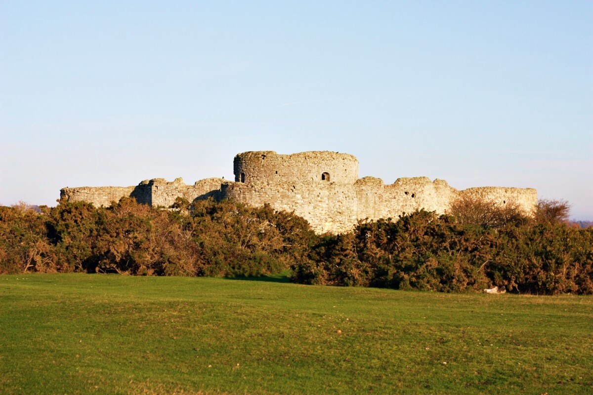
Camber Castle, also known formerly as Winchelsea Castle, is a 16th-century Device Fort, built near Rye by King Henry VIII to protect the Sussex coast of England against French attack
Previous names
Camber Castle
Description
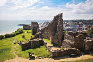
Camber Castle, also known formerly as Winchelsea Castle, is a 16th-century Device Fort, built near Rye by King Henry VIII to protect the Sussex coast of England against French attack. The first fortification on the site was a small, round artillery tower, constructed by Henry between 1512 and 1514, overlooking the Camber anchorage and the entrance to Rye Harbour. In 1539, increasing tensions with France encouraged Henry to rethink his coastal defence plans, and Camber Castle was rebuilt and extended over the next year under the direction of the Moravian engineer, Stefan von Haschenperg. The results were considered unsatisfactory and further work was carried out from 1542 to 1543, at great expense, to rectify the problems. The result was a large, concentric artillery fort, with a central keep, surrounded by four circular bastions and a circular entrance bastion, built from stone and brick.
The finished castle was initially equipped with 28 brass and iron artillery guns and a garrison of 28 men, commanded by a captain. It may have seen service in 1545 when a French fleet attacked the coast, but its operational value was short lived. The Camber and the surrounding harbours began to silt up, becoming unusable by shipping, and the coastline receded away from the fort, eventually placing it well inland. Furthermore, the fort had been superseded by newer European military designs even before it had been completed, and peace with France later in the century removed much of the requirement for the fort. The castle still remained operational up until 1637, when it was closed by King Charles I. With the outbreak of civil war in 1642, much of the fortification was dismantled by Parliamentary forces to prevent it being used by the Royalists.
The ruins became a popular spot for picnics in the 18th and 19th centuries, and was painted by J. M. W. Turner. Plans to redevelop the castle as a Martello tower or as a clubhouse for a local golf course came to nothing, although the property was used in the Second World War, probably as an early warning site. Archaeological interest in the fort increased after the war and in 1967 it was taken into the guardianship of the state, the property being bought from the private owners in 1977. It is now operated by English Heritage, who reopened it to visitors after an extensive programme of conservation between 1968 and 1994. The fort is an unusual example of an unmodified Device Fort and is protected under UK law as a Grade I listed building.
Landscape
Camber Castle now lies on the Brede Level, a wide, reclaimed area of land between the modern towns of Rye and Winchelsea, about 1.5 kilometres (0.93 mi) from the sea.The surrounding pasture land is flat and only just above at sea-level, marked with numerous ridges formed by the retreating coastline over the centuries. On the eastern side of the fortification is Castle Water, a large, 20th-century gravel pit that is now flooded to form a wetland nature reserve.
A 1.8-metre (5 ft 11 in) defensive earthwork runs around the south and east sides of the castle; this was probably originally topped by a stone wall and designed to protect the castle from the sea, which would have then been much closer. The remains of a raised causeway, which once linked the isolated castle to the mainland, leads away for a short distance to the south-west from the earthwork before petering out. Marks from the holes that were dug to provide the materials for the infilling of the bastions in the early 17th century also survive around the outside of the castle.
Architecture
The three-storey castle itself has changed little since its completion in 1544, an incorporates elements from all of the three phases of building work in 1512–14, 1539–40 and 1543–44. It is now roofless but still standing up to 18 metres (59.1 ft) tall, and covers 0.73 acres (0.30 ha), almost as big as the largest of the Device Forts at Deal in Kent. The first tower on the site was built from fine-grained yellow sandstone, with the later expansion making use of both yellow and grey sandstone, with imported Caen stone being used for the finer detailing. Ironstone, siltstone and brown sandstone rubble and boulders was used for the core of the castle walls, some of it taken from the local cliffs.
The castle would have been entered through the entrance bastion. The core of this building was constructed in the second phase of work on the castle and was initially a square one-storey construct, 15 by 10.5 metres (49.2 by 34.4 ft) across, before being extended forward by an additional 9 metres (29.5 ft) to form a circular bastion; an additional floor was then added on top in the third phase. The internal walls have mostly been destroyed, but the ground floor chambers would have been used for administration, and possibly as living rooms for the deputy captain.The first floor would have formed a high-status set of chambers for the use of the captain, and included large windows, fireplaces and a private garderobe, but most of this storey has been destroyed. A special German tile-stove was probably fitted into the chambers for the use of Philip Chute, the first captain of the castle, and was illustrated with pictures of Landsknecht soldiers and Protestant German leaders; only fragments of the stove have survived.
In the centre of the fortification was the keep, built up from the round tower of 1512–14, and 6.7 metres (22 ft) of the original building's walls were incorporated into the new design. The original tower had ten gunports embedded at ground level in its 3.05-metre-thick (10.0 ft) walls, but these were blocked up in the second phase of building. The keep would originally had a parapet running around its roof, which was initially flat but converted to a ridged design in the third phase of work. The ground floor was laid in brick and had a brick and stone-lined well to supply it with water. The keep had two fireplaces, but these were small and not intended for cooking – indeed, the final version of the keep was probably never used as a living space. The first floor windows were added in the final phase of work; they were not intended for use as gunports, but they had bars and shutters, so could have been easily secured in the event of an attack.
An underground vaulted ring passageway, only 1.9 metres (6 ft 3 in) high ran around the outside of the keep, with similar covered radial passageways leading off to each of the bastions; the passageways are now ruined. A cobbled courtyard surrounded the keep, separating it from the external defences, and containing a well in the north-west corner. Underground passageways led from the entrance bastion to outside the castle walls, either to allow the garrison to escape in an emergency or to assault a besieging force.
The outer part of the castle was defended by an octagonal wall, which linked the four stirrup turrets and bastions that formed the main defences for the castle. This wall had initially been built in the second phase of work on the castle, but was then supplemented in the final phase with an additional 2.4-metre-thick (7.9 ft) exterior facing, and was originally finished with a gun embrasure along each section, and parapets. A two-storey gallery, which provided relatively spacious barrack accommodation for the garrison, ran all the way around the inside of the wall, although only the ground floor of the gallery now survives. The gallery would have been lit by windows facing into the courtyard. The Rampire earthwork built in the early 17th century lies across the south and south-east parts of the defences, where the gunports were blocked up with stone when the earth was piled up along the inside of the castle.
The four stirrup towers are two storeys tall, 6 by 6.2 metres (19.7 by 20.3 ft) across internally, with 0.8-metre-thick (2.6 ft) walls, flat at the front and curved at the back. They would originally have been topped by firing platforms, with gunloops around the inside of the fortification enabling their occupants to fire into the courtyard if necessary. The bastions built around the outside of the towers in the third phase of work are 19 metres (62.3 ft) wide internally and each extend 12 metres (39.4 ft) from their respective stirrup tower, with 3.6-metre-thick (12 ft) walls. Most of the bastions had a single internal gun room with a robust gun deck on top, but the West Bastion was used as a kitchen and the interior was fitted with two circular ovens and a range for cooking.The bastions would have been connected by a wall-walk and parapets, but these have since been lost.The south stirrup tower and bastion remains partially buried as a result of the construction of the Rampire.
Useful information
No access via road. Offsite parking is located one mile away.
- Member - Join now Free
- Adult £3.00
- Concession tool-tip £1.50
Child (5-17 years) Free
Assistance dogs only.
External links
Nearby castles