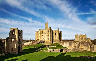
Dunstanburgh Castle
Northumberland England England
castle, chateau
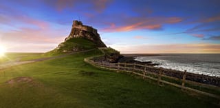
Dunstanburgh Castle is a 14th-century fortification on the coast of Northumberland in northern England, between the villages of Craster and Embleton

Previous names
Dunstanburgh Castle
Description
Dunstanburgh Castle is a 14th-century fortification on the coast of Northumberland in northern England, between the villages of Craster and Embleton. The castle was built by Earl Thomas of Lancaster between 1313 and 1322, taking advantage of the site's natural defences and the existing earthworks of an Iron Age fort. Thomas was a leader of a baronial faction opposed to King Edward II, and probably intended Dunstanburgh to act as a secure refuge, should the political situation in southern England deteriorate. The castle also served as a statement of the earl's wealth and influence, and would have invited comparisons with the neighbouring royal castle of Bamburgh. Thomas probably only visited his new castle once, before being captured at the Battle of Boroughbridge as he attempted to flee royal forces for the safety of Dunstanburgh. Thomas was executed, and the castle became the property of the Crown before passing into the Duchy of Lancaster.
Dunstanburgh's defences were expanded in the 1380s by John of Gaunt, the Duke of Lancaster, in the light of the threat from Scotland and the peasant uprisings of 1381. The castle was maintained in the 15th century by the Crown, and formed a strategic northern stronghold in the region during the Wars of the Roses, changing hands between the rival Lancastrian and Yorkist factions several times. The fortress never recovered from the sieges of these campaigns, and by the 16th century the Warden of the Scottish Marches described it as having fallen into "wonderfull great decaye".As the Scottish border became more stable, the military utility of the castle steadily diminished, and King James I finally sold the property off into private ownership in 1604. The Grey family owned it for several centuries; increasingly ruinous, it became a popular subject for artists, including Thomas Girtin and J. M. W. Turner, and formed the basis for a poem by Matthew Lewis in 1808.
The Dunstanburgh Castle golf course was built near the property in 1900, and expanded by the castle's then owner, Sir Arthur Sutherland, in 1922. By the 1920s Sutherland could no longer afford to maintain the castle, and he placed it into the guardianship of the state in 1930. When the Second World War broke out in 1939, measures were taken to defend the Northumberland coastline from a potential German invasion. The castle was used as an observation post and the site was refortified with trenches, barbed wire, pill boxes and a mine field. In the 21st century the castle is owned by the National Trust and run by English Heritage. The ruins are protected under UK law as a Grade I listed building, and are part of a Site of Special Scientific Interest, forming an important natural environment for birds and amphibians.
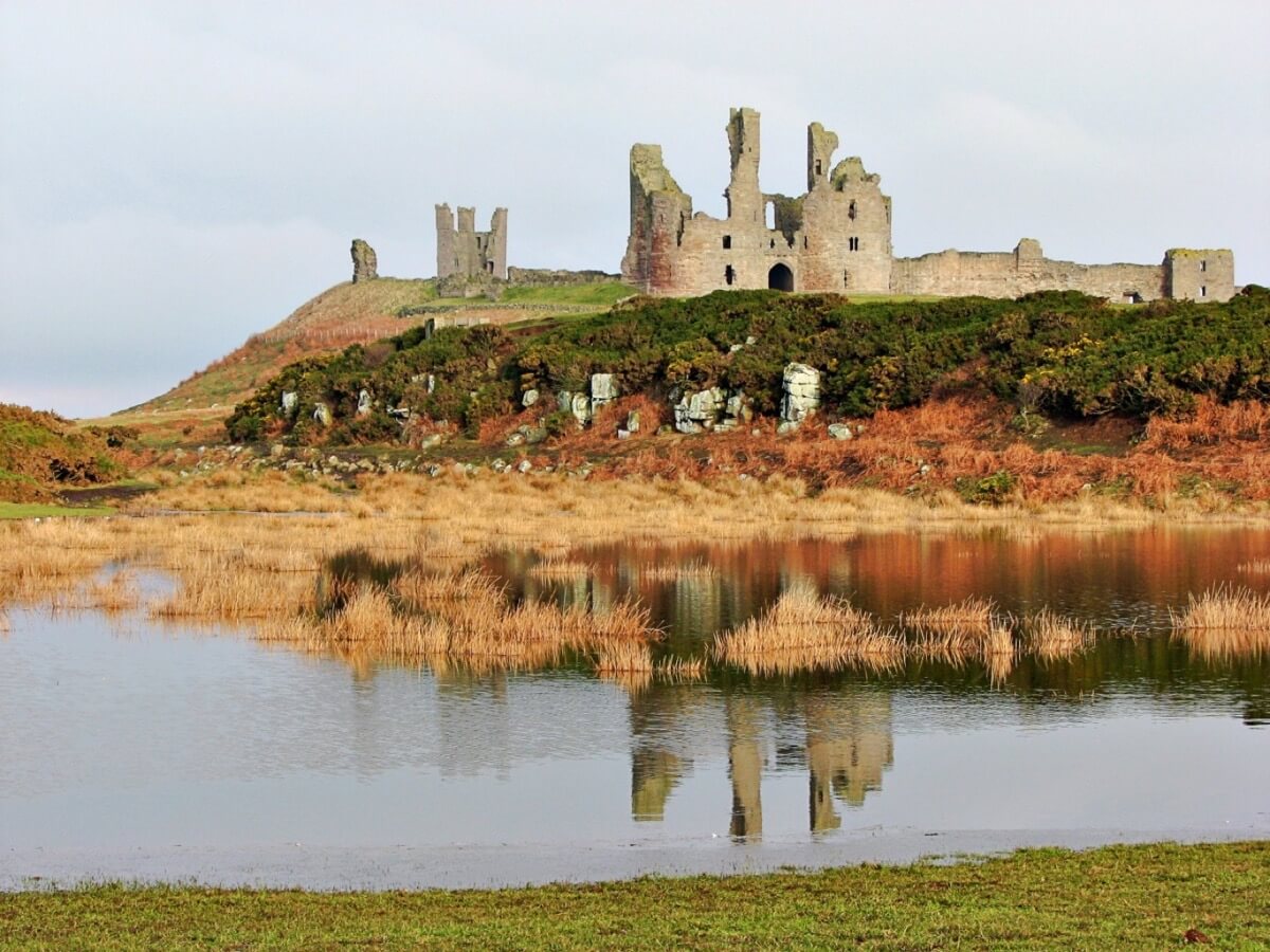
Dunstanburgh Castle was built in the centre of a designed medieval landscape, surrounded by three artificial lakes called meres covering a total of 4.25 hectares (10.5 acres). The curtain walls enclose 9.96 acres (4.03 ha), making it the largest castle in Northumberland. The most prominent part of the castle is the Great Gatehouse, a massive three-storey fortification, considered by historians Alastair Oswald and Jeremy Ashbee to be "one of the most imposing structures in any English castle". Multiple rectangular towers protect the walls, including the Lilburn Tower, which looks out towards Bamburgh Castle, and the Egyncleugh Tower, positioned above Queen Margaret's Cove. Three internal complexes of buildings, now ruined, supported the earl's household, the castle constable's household and the running of the surrounding estates. A harbour was built to the south-east of the castle, of which only a stone quay survives.
Architecture and landscape
Landscape
Dunstanburgh Castle occupies a 68-acre (27.5 ha) site within a larger 610-acre (246 ha) body of National Trust land along the coast. The castle is situated on a prominent headland, part of the Great Whin Sill geological formation. On the south side of the castle there is a gentle slope across low-lying, boggy ground, but along the northern side, the Gull Crag cliffs form a natural barrier up to 30-metre (98 ft) high. The cliffs are punctuated by various defiles, formed from weaknesses in the black basalt rock, including the famous Rumble Churn.
The landscape around the castle was carefully designed in the 14th century as a deer park or planned borough, and would have looked similar to those at the contemporary castles of Framlingham, Kenilworth, Leeds and Whittington; in particular, Kenilworth may have been a specific model for Dunstanburgh.[81] The area around the castle was dominated by three shallow artificial lakes, called meres, and accessed by three gates on the north, west and south sides. The meres were fed from a fresh water spring 2,000 feet (600 m) inland, linked to the meres by an underground stone channel. The meres were originally bounded by a sod-cast boundary bank and ditch; today this is heavily eroded, and up to 3-foot 3 inches (1 m) high. The main route by land into the castle would have been from the village of Embleton, through the West Gate.
The North Mere is 5.6-acres (2.25 ha) large, and is blocked off on its northern end by a sod-cast bank, adjacent to the site of the North Gate. The southern half takes the form of a 331-foot (101 m) long moat, which was recorded as being 18-foot (5.5 m) deep in the medieval period, terminating in the West Gate. The northern part of this mere occasionally floods in the 21st century, creating a temporary lake, and the moated section usually still contains some standing water. The West Mere, covering 2.25-acres (1 ha), stretches away from the location of West Gate and is blocked at the far end by a small, stone dam. Three rectangular fishponds were built alongside the West Mere, the smallest, probably a stew pond for raising young fish, being fed with water from the lake. A protective earthen bank, probably originally reinforced by a timber palisade, ran for approximately 490 feet (150 m) along either side of the West Gate, where a gatehouse was probably built. At the far end of the lake complex was the South Mere, 2.25-acres (1 ha) in size, with the South Gate positioned in its eastern corner.
A harbour was built south-east of the castle, which would originally have been used to receive first building materials, then later senior members of the castle household or important guests. All that remains of the harbour is its 246-foot (75 m) quay, built from basalt boulders, and it may not have been in frequent use during the medieval period, since it could only have been safely used during periods of good weather. West of the castle is a later shieling, the earthwork remains of a longhouse. South of this is a rectangular earthwork, with walls over 3-foot 3 inches (1 m) high, which may have been a siege fortification from 1462. If this is in fact such a siege-work, it would be a unique survival in England from this period.
Architecture
Dunstanburgh Castle's buildings are located around the outside of the fortification's outer bailey, enclosed by a stone curtain wall, which enclose 9.96 acres (4.03 ha), making it the largest castle in Northumberland. Possibly from the very start of the castle, and certainly by the 1380s, the castle buildings formed three distinct complexes supporting the Earl's household, the castle's constable and the administration of the Embleton barony respectively. The inside of the bailey still shows the marks of former strip farming, which can be seen in winter.
The southern and western parts of the walls were originally faced with a local ashlar sandstone with a core of basalt rubble; the sandstone was mostly quarried at Howick. The sandstone has since been stripped from the western parts of the wall, and the sandstone along the eastern end of the walls gives way to small limestone blocks, originally only laid 11-foot (3.3 m) high with a 4-foot 11 inches (1.5 m) parapet, but later raised in height with additional basalt boulders, probably during the Wars of the Roses. It is uncertain if the curtain wall originally extended above the cliffs along the northern edge of the castle.
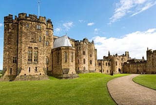
Moving counter-clockwise around the curtain wall from the north-west, the rectangular Lilburn Tower looks out across Embleton beach. The tower was named after an early castle constable, John de Lilburn, but may have been built under Thomas of Lancaster; it was intended as a high-status residence, 59-foot (18 m) high, 30-foot (9.1 m) square with 6-foot (1.8 m) thick walls, with a guardroom for soldiers on the ground floor.[103] The rectangular towers at Dunstanburgh reflects the local tradition in Northumberland, and are similar to those at nearby Alnwick.Further along the wall there are the remains of a small tower, called Huggam's House by local tradition. Earthworks around the inside of the curtain wall suggest that there may once have been a complex of buildings stretching between Lilburn Tower and Huggam's House.
On the south-west corner of the walls are the castle gatehouses. The most prominent of these is the Great Gatehouse, a massive three-storey fortification, comprising two drum-shaped towers of ashlar stone; originally 79-foot (24 m) high. This was heavily influenced by the Edwardian gatehouses in North Wales, such as that at Harlech, but contains unique features, such as the frontal towers, and is considered by historians Alastair Oswald and Jeremy Ashbee to be "one of the most imposing structures in any English castle". In the 1380s this gatehouse was further strengthened with a 31-foot (9.4 m) long barbican, of which only the rubble foundations now survive, around 2-foot 4 inches (0.7 m) high.
The passageway through the gatehouse was protected by a portcullis and possibly a set of wooden gates. The ground floor contained two guardrooms, each 21-foot (6.4 m) wide, and latrines, with spiral staircases in the corner of the gatehouse running up to the first floor, where relatively well-lit chambers with fireplaces probably accommodated the garrison's officers. The staircases continued up to the second floor, containing the castle's great hall, an antechamber and bedchamber, originally intended for the use of Thomas of Lancaster and his family. Four towers extended above the gatehouse's lead-covered roof for an additional two storeys of height, giving extensive views of the surrounding area. This design may have influenced the construction of Henry IV's gatehouse at Lancaster Castle.
Immediately to the west of the Great Gatehouse is John of Gaunt's Gatehouse, originally either two or three storeys tall, but now only surviving at the foundation level. This gatehouse replaced the Great Gatehouse as the main entrance, and would have contained a porter's lodge, defended by a combination of a portcullis and a 82-foot (25 m) long barbican. A inner bailey was approximately 50-foot by 75-foot (23 m by 15 m), defended by a 20-foot (6 m) high mantlet wall, was constructed in the 1380s behind John of Gaunt's Gatehouse and the Great Gatehouse. This complex comprised a vaulted inner gatehouse, 30-foot (9.1 m) square, and six buildings, including an antechamber, kitchen and bakehouse.
Further along the south side of the walls is the Constable's Tower, a square tower containing comfortable accommodation for the castle's constable, including stone window seats. On the inside of the walls are the foundations of a hall and chamber, built before 1351, part of a larger complex of buildings used by the constable and his household, approximately 60-foot (18 m) square. To the west of the Constable's Tower is a small turret that projects from the upper wall - an unusual feature, similar to that at Pickering Castle - and a mural garderobe; and to the east a small oblong turret with a single chamber, 10.75-foot by 7.5-foot (3.28 m by 2.3 m).
In the south-east corner of the walls, the Egyncleugh Tower - whose name means "eagle's ravine" in the Northumbrian dialect - overlooks Queen Margaret's Cove below. A three-storey, square building, 25-foot (7.6 m) across, Egyncleugh Tower was designed to house a castle official, and included a small gateway and drawbridge into the castle, either for the use of the castle constable, or possibly for the local people.
There is a postern gate in the eastern wall, added in the 1450s, and a further gateway in the north-eastern corner, which gave access to Castle Point and Gull Crag below. Along the inside of the curtain walls are the foundations of a yard, 200-foot by 100-foot (61 m by 30 m), and a large rectangular building, usually identified as a grange or a barn. This would have probably supported the administration of the Embleton estates, and have included the auditor's chamber and other facilities.
Interpretation
Early analysis of Dunstanburgh Castle focused on its qualities as a military, defensive site, but more recent work has emphasised the symbolic aspects of its design and the surrounding landscape. Although the castle was intended as a secure bolt-hole for Thomas of Lancaster should events go awry in the south of England, it was however "clearly not an inconspicuous hiding place", as the English Heritage research team have pointed out: it was a spectacular construction, located in the centre of a huge, carefully designed medieval landscape. The meres surrounding the castle would have reflected the castle walls and towers, turning the outcrop into a virtual island and producing what the historians Oswald and Ashbee have called "an awe-inspiring and beautiful sight".
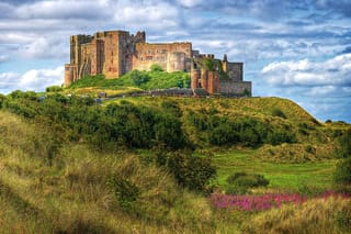
The different elements of the castle were also positioned for particular effect. Unusually, the huge Great Gatehouse faced south-east, away from the main road, hiding its extraordinary architectural features. This may have been because Thomas intended to establish a new settlement in front of it, but the gatehouse was also probably intended to be viewed from the harbour, where the most senior visitors were expected to arrive. The Lilburn Tower was positioned so as to be clearly - and provocatively - visible to Edward II's castle at Bamburgh, 9 miles (15 km) away along the coast, and would have been elegantly framed by the entranceway to the Great Gatehouse for any visitors. It was also positioned on a set of natural basalt pillars, which - although inconvenient to build upon - would have enhanced its dramatic appearance and reflection in the meres.
The design of the castle may also have alluded to Arthurian mythology, which were a popular set of ideals and beliefs among the English ruling classes at the time.Thomas appears to have had an interest in the Arthurian legends, and used the pseudonym "King Arthur" in his correspondence with the Scots. Dunstanburgh, with an ancient fort at its centre encircled by water, may have been an allusion to Camelot, and in turn to Thomas's claim to political authority over the failing Edward II, and was also strikingly similar to contemporary depictions of Sir Lancelot's castle of "Joyous Garde".
Folklore
Dunstanburgh Castle has closely associated with the legend of Sir Guy the Seeker since at least the early 19th century. Different versions of the story vary slightly in their details, but typically involve a knight, Sir Guy, arriving at Dunstanburgh Castle, where he was met by a wizard and led inside. There he comes across a noble lady imprisoned inside a crystal tomb and guarded by a sleeping army.The wizard offers Guy a choice of either a sword or a hunting horn to help free the lady; he incorrectly chooses the horn, which wakes the sleeping knights. Sir Guy finds himself outside Dunstanburgh Castle, and spends the rest of his life attempting to find a way back inside.
It is unclear when the story first emerged, but similar stories, possibly inspired by medieval Arthurian legends, exist at the nearby locations of Hexham and the Eildon Hills. Matthew Lewis wrote a poem, Sir Guy the Seeker, popularising the story in 1808, with subsequent versions produced by W. G. Thompson in 1821 and James Service in 1822. The tale continues to be told as part of the local oral tradition.
Several other oral traditions about the castle survive. One of these involves a child prisoner within the castle, who escaped, throwing the key to her dungeon into a nearby field, sometimes argued to be an outcrop of land north-west of the castle, which from then onwards was infertile. Another centres on a man called Gallon who was left in charge of the castle by Margaret of Anjou and entrusted with a set of valuables; captured by the Yorkists, he escaped and later returned to reclaim six Venetian glasses. The historian Katrina Porteous has noted that in the 14th century there are records of receivers and bailiffs at the castle called Galoun, potentially linked to the origins of the Gallon of this story.
There are local stories of tunnels stretching from Dunstanburgh Castle to Craster Tower, Embleton and Proctor Steads, as well as a tunnel running from the castle well to the west of the castle. These stories may be linked to the presence of the drainage system around the castle.
Useful information
Pay and display car parking (not NT) is available at Craster before the village. Please do not park in the village. The Castle is about a 1 mile walk from the car park.
dunstanburghcastle@nationaltrust.org.uk
Ruined
- Dogs on leads only
- Suitable for school groups
External links
Nearby castles