Castle of Moura
Moura Beja Portugal
castle, chateau
Castelo de Moura
Moura Beja Portugal
castle, chateau
The Castle of Moura (Portuguese: Castelo de Moura), is a Portuguese medieval castle in civil parish of Moura (Santo Agostinho e São João Baptista) e Santo Amador, in the municipality of Moura, in the district of Beja
O Castelo de Moura, no Alentejo, localiza-se na freguesia de São João Baptista, concelho de Moura, distrito de Beja, em Portugal
Previous names
Castle of Moura, Castelo de Moura
Description
The Castle of Moura (Portuguese: Castelo de Moura), is a Portuguese medieval castle in civil parish of Moura (Santo Agostinho e São João Baptista) e Santo Amador, in the municipality of Moura, in the district of Beja.
History
The construction of the Moorish walls began in the middle of the 11th century and lasted to 12th century, probably over a castro dating to the Iron Age settlement. The site successively occupied by the Romans, the Visigoths and Muslims, who turned the town into the capital of the Al-Manijah province.
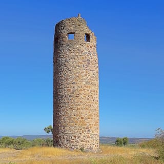
In 1166, as legend relates, the princess Salúquia, daughter of Abu-Hassan and governor of the city, fell in love with Bráfama, the Moorish mayor of Aroche. On the eve of their marriage, Brfafama went with a party to Al-Manijah, ten leagues away. But the entire Alentejo territory to the north and west had already been conquered by the Christians and the journey proved dangerous. Pedro Rodrigues and his brother, being aware of the wedding preparations that were taking there, ambushed Brfafam's party in an olive grove near the limits of the village and easily defeated and killed. The Christians then disguised themselves in the robes of their Muslim foes and headed for the town. Meanwhile, Salúquia was at the top of the castle tower, where she awaited the arrival of her fiancé. Seeing that a group of seemingly Islamic knights were approaching, the princess believed them to be Aroche's entourage, and allowed them to cross the fortification gates. But as soon as they entered, the Christians threw themselves upon the defenders of the city. Taken by surprise, the Muslim forces were defeated. Realizing her error and wounded by the certainty of Brafama's death, she took the keys of the town and rushed from the tower. Moved by the love story that the Islamic survivors told them, the Rodrigues brothers renamed the town Terra da Moura Salúquia, but over time the name would devolve to Terra da Moura, later Moura. A mud-brick tower (taipa) within the Castle of Moura is still referred to as Salúquia Tower, and an olive grove in the vicinity of Moura, where Brfafama and his entourage were ambushed, the people call Brfafama de Aroche. Moura's coat-of-arms would eventually incorporate figure of a dead Moor, with the tower in the background, alluding to the legend of Moor Salúquia.
A foral (charter) was issued by King D. Afonso I, later confirmed in 1217 by his successor, D. Afonso II, during a seesaw period when the region oscillated between Portugal and the Moors. In 1295, Moura became a definitive part of the Kingdom under the reign of King D. Dinis, and a new foral issue in 1295, followed by a similar foral issued to the Moor community. At the beginning of the 14th century, the castle incorporated the Moorish fortifications.
In 1320, a third of the land rents from churches in Serpa and Moura were donated by the Order of Aviz for the reconstruction and maintenance of the castles. New reforms were carried out in the second half of the century by order of D. Fernando, when the growth of the village demanded the extension of its borders and a second line of walls were necessary. A second series of fortifications were begun in the second half of the 14th century, under the initiative of D. Fernando.
Between the 15th- and 16th-century there were several alterations, under the direction of Francisco de Arruda, that included the construction of the wall separating the dungeon and the Salúquia and clock towers.Designs by Duart de Armas, represent the castle as an irregular plan, that includes castle with barbican connected to the town wall. A new foral was issued in 1512, by King D. Manuel I. At the same time, Dominicana nuns decided to building within the walls, in 1562, a convent within the castle walls, under the direction of D. Ângela de Moura, taking advantage of the foundations of the mosque.
The medieval fortress was reinforced in 1655, during the Restoration Wars, with the construction of a line of walls and defended by bastions, by Nicolau de Langres, under the initiative of King D. John IV.
The walls of the fortress were dynamited in 1707, following the withdrawal of the Duke of Ossuna, during the Succession Wars. It was further damaged in 1755, following the Lisbon earthquake. These events marked a period of decline for the castle and fortifications, as in the proceeding years the taipa material were removed from the walls and reused. In 1850, the western wall of the dungeon was demolished by José Pimenta Calça, in order to construct the lagar of Vista Alegre. By 1875, the convent was finally abandoned.
But, sometime in the 19th century, the clock tower was constructed. Work on recuperating the site began in 1959 with consolidation of the towers and walls, followed by successive years of work on other portions of the wall fortifications: in 1964, along the north wall; between 1968 and 1970, consolidation of the walls; and 1971, repairs to the dungeon. Also, the church was reconstructed in 1972, but reworked in 1977, in addition to the recuperation of the area near the former-convent. Archaeological excavations by Jorge Pinho Monteiro were executed in 1981.
On 8 March 2002, a public tender was announced in the Diário da República (issue 57), for the adjudication contract to improve the castle landscape. This move resulted in further classification attempts, such as the 2005 proposal to classify the modern fortification, by the local authority. This was complimented on 31 January 2006, by the opening of a process by IPPAR/DRÉvora on 11 January. A special protection zone for each of the walls was established on 30 November 2010 by the DRCAlentejo. These proposals were prorogued on 30 December 2010, following discoveries onsite. In 2011, archaeological excavations realized during construction of the tourist reception buildings discovered funerary tombs from the Roman period (specifically the 1st century), as well as the some buildings.
Architecture
The castle is erected on an elevated hilltop in the northeastern edge of the town, approximately 184 metres (604 ft) above sea level, at the confluence of the Rio Ardila, the ravines of Brenhas and Lavandeira. Within the barbican is the Dominican convent, near the entrance to the dungeon, with its church oriented to the principal facade.
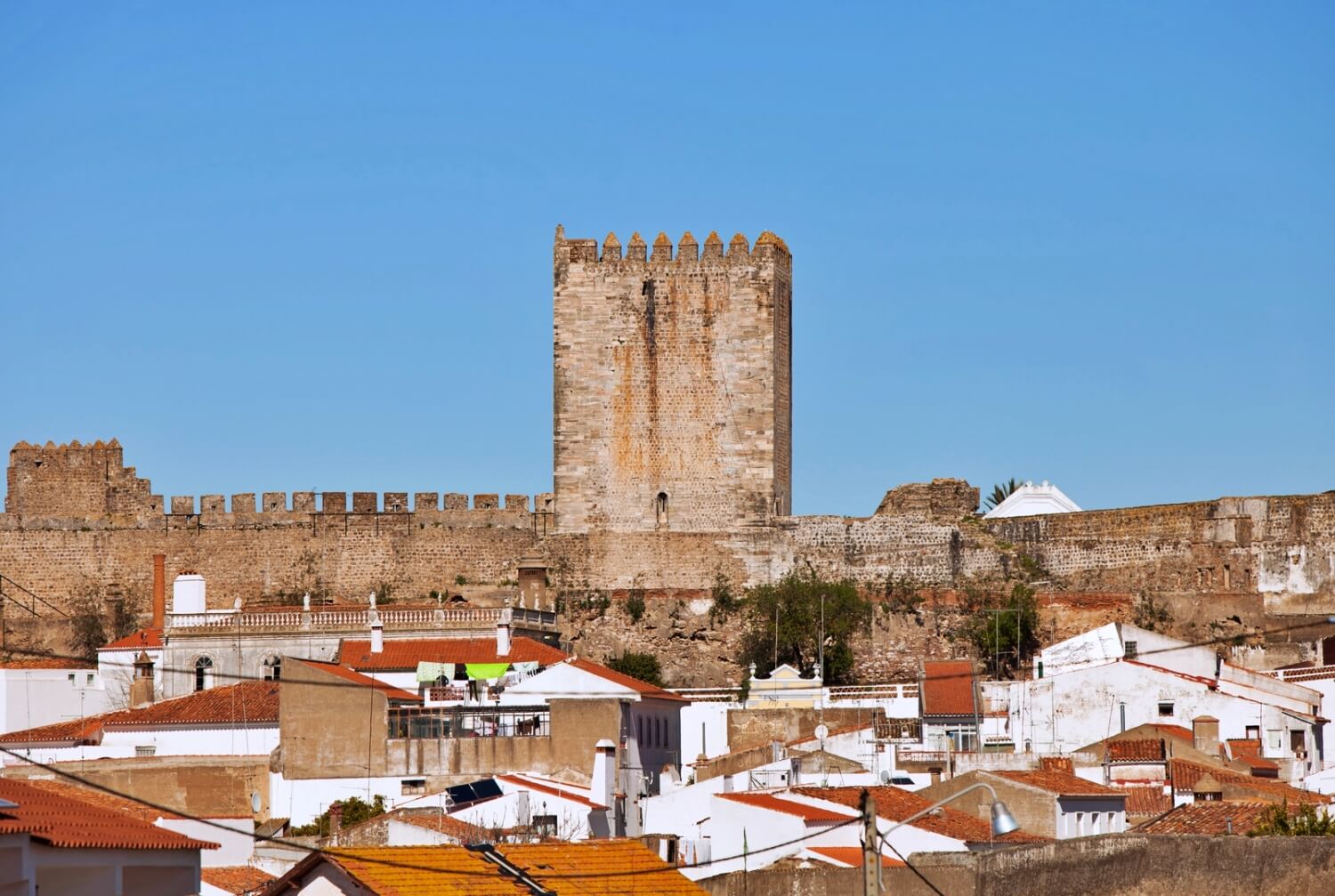
The castle consists of an oval plan, 200 by 120 metres (660 ft × 390 ft) maximum dimensions, occupying the alcazaba in the southwest. It is separate from the rest of the spaces by a line walls, reinforced in the middle by a rectangular keep tower, flanked by a minor tower and by a semi-circular corbel along the wall to the north. The keep tower and circular corbel of the alcazaba includes prismatic merlons with pyramids. Meanwhile, the keep tower has a vaulted first floor ceiling with ribbed ogival, supported by 8 slender columns, known as the Sala dos Alcaides (Alcalde's room). It is crossed by a corridor connected that connects it to the Chemin de ronde and the terrace. On the wall to the alcazaba are vestiges of square towers. Along the circus are still part segments of the walls of the northern barbican, trapezoidal tower, a clock-tower and two circular towers with rear chamfers: the tower of Selúquia (in the northeast) clocktower (in the southeast).
The semi-destroyed tower of Selúquia, with posterior wall includes an archway with access that accompanies terrace. The clocktower is covered by a battlement covered in prismatic merlons, with a square tower, and crossed by a corridor that provides access to the terrace. Most of the walls are still vertical and include chemin de ronde without merlons. Of the gates and doors situated along the wall: the Alcazaba door, that separates the circus from the castle, between the keep and minor tower; the main gate, in the southeast, broken by arch over posts, inscribed in alfiz, that provides access to an elbow corridor that passes under the library building; and a small door, in the northwest along the wall.
Convent
The Church and Convent of São Domingos comprises a rectangular church with addorsed chapel (on the south), surrounded by various rectangular dependencies associated with the convent (in the north and east) and belltower (in the north). The principal facade with gable is topped by windings, includes two rectangular spans and 3 arches with access to the galilee, covered by vaults ceiling over corbels. In the southern lateral facade is a counter-curved doorway. The ruined door to the convent along the presbytery is distinguished by a coat-of-arms carved into the tympanum.
The unique nave is covered in tile with a high-choir over the galilee and part of the nave. On the epistle side is a lateral chapel with a Manueline tomb that hosts the two brothers, Pedro and Álvaro Rodrigues, the two alleged strategists that conquered the village in 1166. The main altar is covered with a vaulted ceiling open to the nave by rounded triumphal arch over pilasters.
O Castelo de Moura, no Alentejo, localiza-se na freguesia de São João Baptista, concelho de Moura, distrito de Beja, em Portugal.
Erguido em posição dominante sobre a vila, na confluência da ribeira de Brenhas com a ribeira de Lavandeira, tributárias do rio Ardila, à margem esquerda do rio Guadiana, inscreve-se atualmente em área de Reserva Natural. A sua defesa era complementada, a partir do século XIII, pelas atalaias da Cabeça Gorda, da Cabeça Magra, de Porto Mourão e de Alvarinho. Esta vila está ligada à História do Brasil pela ação do Regimento de Moura, em tempos coloniais.
História
Antecedentes
Acredita-se que a primitiva ocupação humana deste sítio remonte a um castro da Idade do Ferro, sucessivamente ocupado pelos Romanos, pelos Visigodos e pelos Muçulmanos, quando alcançou expressão regional como capital da província de Al-Manijah, conforme os diversos testemunhos arqueológicos atualmente recolhidos ao Museu Municipal de Moura. A construção da fortificação Muçulmana, em taipa, datará dos meados do século XI ao início do século XII, da qual nos chegaram alguns vestígios, como a chamada Torre da Salúquia.
O castelo medieval
À época da Reconquista cristã da Península Ibérica, a povoação foi inicialmente conquistada, em 1166, pelos irmãos Pedro e Álvaro Rodrigues e perdida quase de seguida. Foi, ainda em 1166, conquistada por Geraldo Sem Pavor, tendo depois disso, e até ao reinado de D. Dinis, sido perdida e reconquistada mais quatro vezes.
Recebeu Carta de Foral outorgada por D. Afonso Henriques (1112-1185) em 1171. O foral da vila seria confirmado, em 1217, por D. Afonso II (1211-1223). O definitivo domínio cristão da região, entretanto, só seria alcançado a partir de 1232.
Sob o reinado de D. Dinis (1279-1325), a povoação recebeu nova Carta de Foral (9 de Dezembro de 1295, privilégio estendido à comunidade moura em 1296 e renovado em 1315), procedendo-se a reconstrução do castelo, aproveitando-se as antigas muralhas muçulmanas. Para esse fim a Ordem de Avis fez doação de um terço das rendas das igrejas de Moura e Serpa para "refazimento e mantimento dos alcáceres dos ditos castellos" (1320). Para complemento das obras empreendidas nos castelos de Moura e de Serpa, foi erguida neste período uma linha de torres de vigilância cobrindo a raia, das quais sobrevive a Atalaia da Cabeça Magra.
Na segunda metade do século XIV, sob o reinado de D. Fernando (1367-1383), iniciou-se uma segunda cerca amuralhada, envolvendo os novos limites da povoação, aumentados. Quando de seu falecimento, abrindo-se a crise de 1383-1385, a vila e seu castelo tomaram partido por D. Beatriz e João I de Castela até à época da batalha de Aljubarrota.
Sob o reinado de D. Manuel I (1495-1521), a vila e seu castelo encontram-se figurados por Duarte de Armas (Livro das Fortalezas, c. 1509), com destaque para a Torre de Menagem rodeada por muralha torreada, onde se rasga o portão em arco apontado, enquadrado por alfiz e heráldica. Em 1512, o soberano outorgou o Foral Novo à vila. Por essa época seriam iniciadas obras de modernização das suas defesas com risco de Francisco de Arruda. Mais tarde, ainda neste período, seria iniciado, por D. Ângela de Moura, em 1562, o convento feminino de São Domingos, no interior da cerca, sobre as fundações da antiga mesquita.
Da Guerra da Restauração aos nossos dias
No contexto da Guerra da Restauração da independência portuguesa, o Conselho de Guerra de D. João IV (1640-1656), determinou a modernização e reforço da antiga fortificação, dada a sua posição estratégica na fronteira com a Espanha. Desse modo, com projeto a cargo de Nicolau de Langres, foi erguida uma linha abaluartada, envolvente da povoação, reforçada por revelins. É ainda, deste período, o chamado Edifício dos Quartéis, originalmente um conjunto de casernas integrado pela Capela do Senhor Jesus dos Quartéis em uma das extremidades.
Ocupada durante a Guerra de Sucessão da Espanha, fizeram-se explodir as muralhas de Moura (danificando parte da Torre da Salúquia), na seqüência da retirada das forças espanholas sob o comando do duque de Ossuna (1707). Nesse século sofreu novos danos por conta do terramoto de 1755.
Desguarnecida a partir de 1805, entre 1809 e 1826 os antigos muros de taipa do castelo foram usados como matéria prima para o fabrico de salitre. Posteriormente, em 1850, José Pimenta Calça fez demolir o troço Oeste do muro da alcáçova, para dar lugar ao lagar de Vista Alegre.
O terreno do Castelo de Moura e o próprio castelo foi comprado em 1915 por Tiago Romano. As ruínas do Convento das freiras Dominicanas e Igreja anexa encontram-se classificados como Imóvel de Interesse Público por Decreto publicado em 27 de Março de 1944. Ao final da década de 1950 iniciou-se a intervenção do poder público, através da Direcção-Geral dos Edifícios e Monumentos Nacionais (DGEMN), estendendo-se pelas duas décadas seguintes. Em 1981 foram procedidas sondagens arqueológicas no interior do perímetro do conjunto, tendo se procedido a trabalhos de reparo e recuperação em 1982 e entre 1985 e 1986. Mais recentemente, em 2002, foram procedidos trabalhos de valorização paisagística do entorno do castelo.
Recomenda-se a visita ao Museu Árabe, erguido em torno do antigo poço que abastecia o castelo.
Características
Sobre uma elevação calcário, na cota de 184 metros acima do nível do mar, o castelo compõe-se por alcáçova e barbacã de planta ovalada, com as dimensões máximas de 200 x 100 metros. Em seu interior localizam-se as ruínas do Convento de Freiras Dominicanas de Nossa Senhora da Assunção (abandonado desde 1875) e da igreja anexa, erguidos a partir de 1562 no local da primitiva Igreja Matriz, junto à entrada da alcáçova, para onde se volta a fachada da igreja. Esta é de planta rectangular e nave única, nela se destacando o túmulo, em estilo manuelino, de Pedro e Álvaro Rodrigues, supostos conquistadores de Moura aos muçulmanos em 1166, e protagonistas da lenda de fundação da vila.
A alcáçova é acessada por uma porta em cotovelo, a Sudeste. O conjunto é dominado pela torre de menagem, dionisina, de planta quadrada. Ladeando-a, identificamos a base maciça de outra torre, menor, e ainda um cubelo circular, na junção com a muralha exterior. Tanto a torre de menagem, quanto o cubelo apresentam merlões prismáticos piramidais. Em alguns trechos da muralha ainda subsiste o adarve. A cerca externa é reforçada por torres de planta quadrangular e circular. No século XIX uma das torres foi adaptada a Torre do Relógio.
A torre de menagem, em estilo gótico, maciça na parte inferior, tem no segundo pavimento uma sala de planta octogonal (Sala dos Alcaides) coberta por abóbada em cruzaria de ogivas, assente em oito colunas de fuste delgado.
A linha abaluartada do século XVII apresenta planta no formato estrelado, com muro rampante (em alambor), originalmente cercado por fosso, hoje quase que totalmente encoberto.
Useful information
Free
Free
- Castle Gardens
- WC
- Great view
- Ruins of the castle
- The Castle has museums
-
External links
Nearby castles