Clitheroe Castle
Lancashire England England
castle, chateau
Clitheroe Castle is a ruined early medieval castle in Clitheroe in Lancashire, England
Previous names
Clitheroe Castle
Description
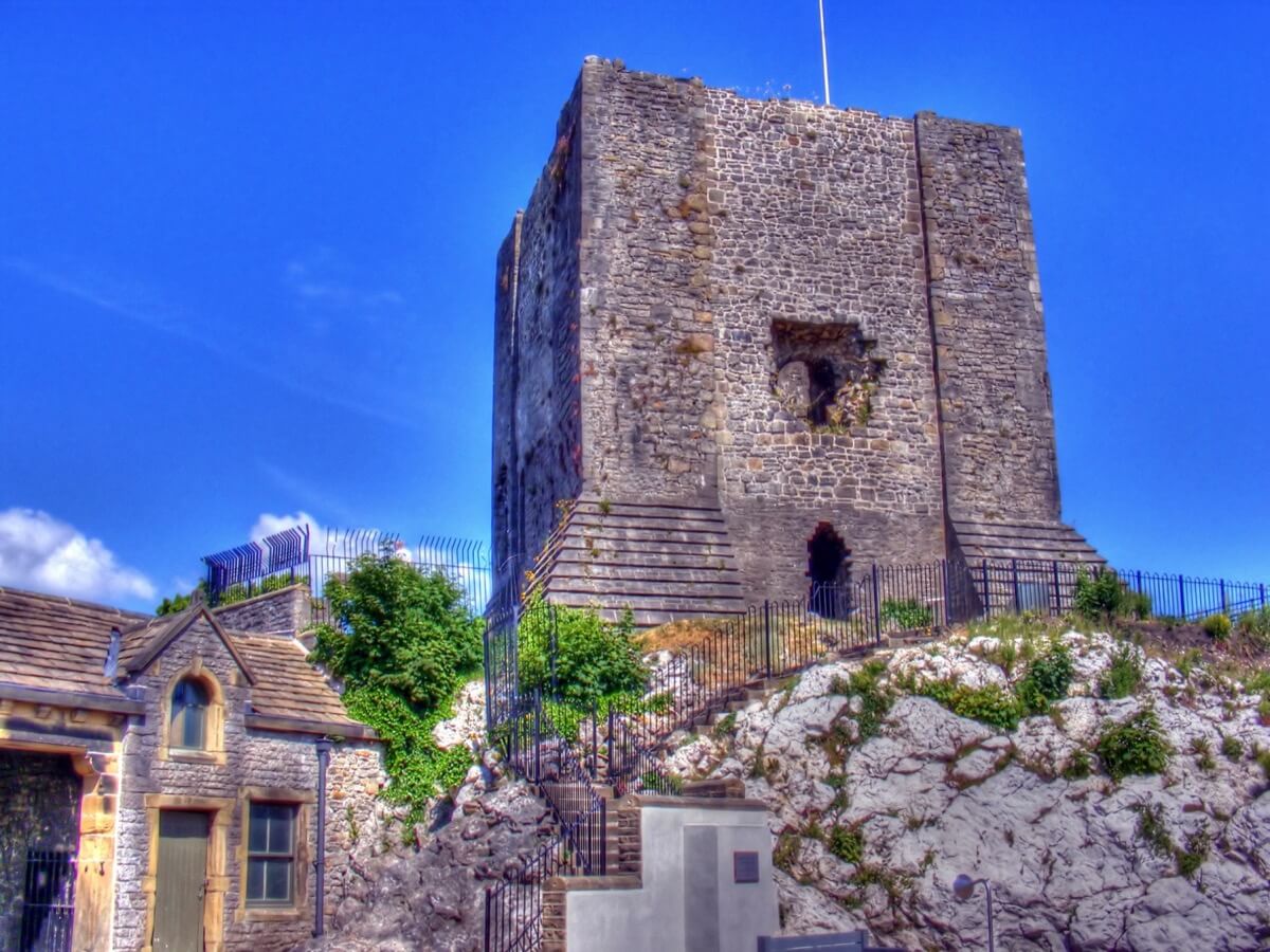
Clitheroe Castle is a ruined early medieval castle in Clitheroe in Lancashire, England. It was the caput of the Honour of Clitheroe, a vast estate stretching along the western side of the Pennines.
Its earliest history is debated but it is thought to be of Norman origin, probably built in the twelfth century. Property of the de Lacy family, the honour later merged with the earldom and then Duchy of Lancaster. Given to George Monck, 1st Duke of Albemarle in 1660, the castle site remained in private ownership until 1920, when it was sold to the people of Clitheroe to create a war memorial. Today the buildings on the site are the home of Clitheroe Castle Museum.
The keep is the second smallest surviving stone-built keep in England. The castle was listed as a Scheduled Monument on 10 April 1915 (and later, under the Ancient Monuments and Archaeological Areas Act 1979 law). It was Grade I listed on 19 May 1950.
Layout
The Historic England scheduled monument record classifies Clitheroe as an enclosure castle, the principal defence being the wall surrounding the site. It was essentially a motte-and-bailey layout, with a natural outcrop utilised as the motte. The keep is the second smallest surviving stone-built keep in England. It's thought that, as the keep was so small, other essential buildings, such as the great hall may have been located on the site where the education suite now stands. A 1602 survey mentions Mr Auditor's chamber, the hall and buttery,and there would likely also have been stables and lodgings for any stationed soldiers. The southwest corner of the site next to the Steward's house was formerly the kitchen gardens. The medieval castle keep and some of the curtain wall remain above ground, although the medieval buildings in the bailey have not survived. However, there are sub-surface remains of the castle gateway and other buildings. A document from 1304 mentions ditches and moats, thought to be a distance from the castle at a lower level, but these have since been filled in. The footpath that ascends the castle mound to the keep, and the western access road are believed to be later additions.
Keep
The keep is square tower with flat pilasters at the corners giving the appearance of corner towers, with the walls being 8.75 feet (2.7 m) wide at the base. The ground floor, is thought to have been accessed from above via a trapdoor, with recessed arrowslits in the middle of the walls on three sides, except the northwest. Two of these have been converted into entrances, with the other, on the southwest side, filled-in. The main entrance to the keep was on the first floor on the northwest side, accessed by an external staircase. Next to this, in the western corner tower is the lower entry to a spiral staircase, which today rises to a height of 46 feet (14.0 m) from the ground, somewhat higher than the other surviving walls. It is thought that the keep would have had a parapet with at least one turret above the staircase. The first floor also had another door in the southwest wall with recessed arrowslits in the other walls. The doorway may have led to the ramparts of the adjacent curtain wall. What today appears to be another doorway next to this, leading by a right-angled passage into the keep, was actually a barrel vaulted mural chamber, which seems to have had an arrowslit in the wall at this end, now breached.This chamber may have been a garderobe, but this is debated. The walls above show no signs of any wall openings even to the staircase.The re-building work may have removed any evidence of a doorway to what may have been may have been a second floor of sleeping accommodation, or the walls may have concealed a pitched roof, similar to the keep at Peveril There is also no evidence of fireplace openings in any part of the keep. The repairs made during the restoration work used limestone from quarries at the nearby village of Chatburn, making the additions identifiable.
The hole
The first-floor arrowloop on the southeast side has today widened, most likely the result of natural decay.There is an ancient local legend that the Devil once gathered rocks in an apron, and threw a boulder aimed at the castle, from a place on Pendle Hill called Apronful. However the apron broke, dropping a pile of stones and causing the shot to land near the church in Pendleton. The guidebook to the castle relates this local tale, "they always said that the hole in the side of the keep was made by Cromwell in the Civil War. It's only a story but they say that he attacked the castle and fired at it with a cannon from the top of Pendle Hill – it must have been a good cannon for the time to reach that far!"
Gatehouse and curtain wall
It is thought the gatehouse tower stood approximately at the site of the stone gate piers on the drive up to the museum. A tall embattled wall, it is believed, ran round the top of the hill, turning behind the steward's house, and then behind the steward's gallery and around the keep. A 16th century sketch shows a four-sided, two-story gatehouse with a Norman round-headed doorway, the door including a wicket gate, a small part may be preserved in the wall to the east. Possibly similar the one at Tickhill, the upper floor may have served as a lodging for the castle porter who acted as the jailer. To the west, the remains of the curtain wall climb the slope, connecting to the wall at the top. It has been suggested that the 6 foot (1.8 m) wide wall that surrounds the keep on three sides may represent an earlier construction phase than the keep itself. It may have been a shell keep containing a number of lean-to buildings, with the southern section later demolished and the present keep built inside. Like the keep this section of wall was re-built in the mid-19th century, with the work distinguishable from the original, the north-western exterior face being best preserved. A section of western curtain wall survives next to the well, now separated from the other walls by the stables and court house buildings. The bailey is thought to have been divided into an inner and outer section, with a second gatehouse and/or defensive ditch to control the entry, of which no trace survives. The garden terraces that were created in the mid-18th century cut-up much of the site and making difficult to identify the castle's limits.
Chapel of St Michael de Castro
The chapel of St. Michael within the castle in mentioned in charters from 1120, and was ecclesiastically separated from the ancient parish of Whalley. Some records call it extra-parochial and it is sometimes described as the parish church of the castle and demesne, with the forest districts of the honour. The chapel had reinforced walls and formed part of the inner bailey wall, and was located at the southern end of the terrace next to the old stable block. When Henry de Lacy (c.1251–1311) gave Whalley to the monks of Stanlaw (Whalley Abbey), he withheld the chapel and its district. In 1334, the Abbey entered a legal battle for control over it, finally purchasing the advowson from John of Gaunt in 1365. After the Dissolution of the Monasteries in the late 1530s, the benefactions it had received under the monks being transferred to the chapel at Whitewell. The chapel was in ruins in 1660, and the allowance for the chaplain was transferred to St Mary Magdalene's Church. By 1717 nothing but the decayed walls remained.
Great hall
The inner bailey probably also contained the great hall. A document dated 1324 refers to the rebuilding of a structure, which given the large quantities of material and labour required, would have been on an appropriate scale. The materials included 30 wagon-loads of timber from Bowland with a further 12 loads from Leagram Park and 45 wagon loads of stone slates for the roof. The work took five carpenters over 17 weeks to complete.
The Hundred court was held here, with the steward of the honour acting as judge, originally every three weeks. At some time probably in the 12th century this changed to twice a year, with the three-week court continuing but being limited to claims less than 40 shillings. The demesne manors instead held halmote courts, with those for Chatburn, Worston and Pendleton also being held at the castle.
Jail
The castle is known to have acted as a jail, and important men were occasionally imprisoned there. Henry VI may have been held briefly as he was captured outside Clitheroe in 1464, during the Wars of the Roses. In 1506 the porter was imprisoned in his own jail after attending a meeting of armed men at Whalley. Whether the keep was used as the jail is uncertain; there may have been a separate dungeon elsewhere in the bailey.
Museum
Main article: Clitheroe Castle Museum
Today the buildings on the castle site form Clitheroe Castle Museum. The museum is based in the former Steward's House, a Grade II listed building, originally built in the 18th century, with later additions and modifications. The former courthouse, is now a temporary exhibition space called the Steward's Gallery. The museum was originally opened in 1954 in the Steward's Gallery. It underwent a £3.5-million refurbishment and redevelopment, and officially opened on 23 June 2009 by Prince Richard, Duke of Gloucester. Its social history collection contains about 5,000 items, and the geology collection includes four type and figured specimens. It also has smaller collections of natural history, local art and period costume, and the archaeology collection includes items recovered from excavations on the site.
Castle grounds
The 6.4-hectare (16-acre) castle grounds site was established as a public park after the castle site was acquired by the council. Of the £15,000 raised in 1920, £9,500 was spent to purchase the site, and the rest used laying out the park. It incorporates the early 18th-century garden terraces created for the steward's residence. Bowling greens, tennis courts, a putting green, a bandstand and pavilion café were installed, and specimen trees planted as part of the landscaping include a fern-leaf beech and a dawn redwood. The war memorial, a sculpture of a soldier standing atop a pedestal in a mourning pose with head bowed and arms reversed, is located south of the keep. The main inscription reads "Erected by the inhabitants of Clitheroe in grateful remembrance of their fellow townsmen who gave their lives in defence of their king and country in the Great War 1914 1918". The sculptor was Louis Frederick Roslyn, and the same figure is used in the memorial at Slaidburn. There is also a memorial plaque to those killed in the Second Boer War, installed in 1907.
The centrepiece of the old rose garden south of the castle is a turret from the Houses of Parliament, presented to the borough by its MP (Sir William Brass) in 1937, in commemoration of the coronation of King George VI. Also known as the Pinnacle, it dates back to the mid-1800s rebuilding work at the Place of Westminster. Clitheroe Civic Society has been running a project to restore the monument after it was discovered that corroding iron fixings have been damaging the stonework.
In April 2006, a new skatepark officially opened in the Woone Lane corner of the castle grounds, the £200,000 cost funded by the Lancaster Foundation charitable trust.Also opened in 2006 is a turf labyrinth designed by Jim Buchanan. In 2010, ten plaques featuring key events in the history of Clitheroe where installed on the walls of the creative activity area next to the keep. To commemorate the 400th anniversary of the trials of the Pendle witches, a new long-distance walking route called the Lancashire Witches Walk has been created. Ten tercet waymarkers, designed by Stephen Raw, each inscribed with a verse of a poem by Carol Ann Duffy have been installed along the route, with the fourth located here.
The town's annual Guy Fawkes Night bonfire fireworks display is among a number of regular events staged.
Castle Hill
The keep is on the summit of a large carboniferous rock, which is the highest and most prominent point for miles around. This is now identified as a Waulsortian mudmound. The rock comprises light grey, unbedded, micritic limestone, heavily jointed with calcite veining. There is some galena and sphalerite mineralisation in the joints. It is rich in fossils: mainly Crinoid ossicles together with gastropods and brachiopods. There has been much debate on how these mud mounds were formed. One theory led to them being called reef knolls, knoll reefs, or bioherms but work in 1972 by Miller & Grayson explained their structure. Clitheroe Castle is the most southwesterly of a chain of mudmounds in the Bowland Sub-basin of the Craven Basin, that has been dubbed the Clitheroe 'Reef' Belt. They include important geological sites at Salthill and Bellman quarries, Crow Hill and Worsaw, Gerna and Sykes.
Useful information
New market street - FREE
Ruined