Blh
castle ruin
420m
Veľký Blh, Banská Bystrica county

The ruins of the castle in the game reserve above the village of Veľký Blh, at the top of the extended ridge between Dlhý Vrch and Hradište

https://media.whitetown.sk/pictures/sk/blh/blh2.jpg
https://media.whitetown.sk/pictures/sk/blh/blh1.jpg
https://media.whitetown.sk/pictures/sk/blh/blh3.jpg
https://media.whitetown.sk/pictures/sk/blh/blh4.jpg
https://media.whitetown.sk/pictures/sk/blh/blh5.jpg
https://media.whitetown.sk/pictures/sk/blh/blh6.jpg
https://media.whitetown.sk/pictures/sk/blh/blh7.jpg
https://media.whitetown.sk/pictures/sk/blh/blh8.jpg
https://media.whitetown.sk/pictures/sk/blh/blh9.jpg
https://media.whitetown.sk/pictures/sk/blh/blh10.jpg
https://media.whitetown.sk/pictures/sk/blh/blh11.jpg
https://media.whitetown.sk/pictures/sk/blh/blh12.jpg
https://media.whitetown.sk/pictures/sk/blh/blh13.jpg
https://media.whitetown.sk/pictures/sk/blh/blh14.jpg
https://media.whitetown.sk/pictures/sk/blh/blh15.jpg
https://media.whitetown.sk/pictures/sk/blh/blh16.jpg
https://media.whitetown.sk/pictures/sk/blh/blh17.jpg
https://media.whitetown.sk/pictures/sk/blh/blh18.jpg
https://media.whitetown.sk/pictures/sk/blh/blh19.jpg
https://media.whitetown.sk/pictures/sk/blh/blh20.jpg
https://media.whitetown.sk/pictures/sk/blh/blh21.jpg
https://media.whitetown.sk/pictures/sk/blh/blh22.jpg
https://media.whitetown.sk/pictures/sk/blh/blh23.jpg
https://media.whitetown.sk/pictures/sk/blh/blh24.jpg
https://media.whitetown.sk/pictures/sk/blh/blh25.jpg
https://media.whitetown.sk/pictures/sk/blh/blh26.jpg
Previous names
Balog, Bolug, Bolugh, Bolock, Balogwara, castrum Balogh, Balogvár
You need to sign in to save your wishes
How to get there
Road 1
40 min
+112m/0m
Trasa 1: Between the villages of Veľký Blh and Teplý Vrch, we turn right onto a narrow asphalt road that will lead us to the gate of the game reserve - the Teplý Vrch. If we want to enter the field by car, it is necessary to obtain a permit to enter the complex in advance. We recommend a permit even if we leave the car in front of the gate and complete the entire route on foot. This is mainly for your safety, as it is a hunting ground and hunting can take place around the castle. So we leave the car in front of the gate. We will open the gate and walk from it on the asphalt road. After about 30 minutes we come to a small crossroads, from where we continue a few meters to the right along the road and from there we go right again to the edge of the forest. We walk about 100 m along the edge and enter the forest on the right. Here we already notice a wooden railing and a relatively short ascent to the ruins of the castle follows, but about 40 meters of elevation gain on such a short section will test our skills.
Road 2
5-10 min
+40m/0
Trasa 2: We will save a considerable part of the route if we complete the journey from the gate to the crossroads mentioned in route no. 1 by car (entry permit required). We then park the car at the edge of the road junction, from where we continue on foot as well as on route no. 1 in a few minutes to the castle ruins.
Description

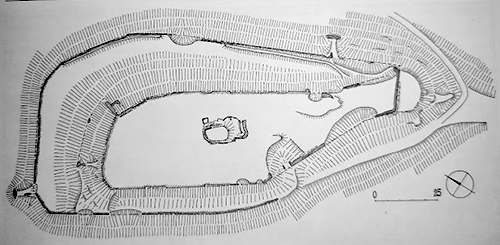
The relatively large castle with dimensions of approximately 150x70 m had a small core, which partially occupied the top plateau of the central rock. Two stone walls stretched around the core. In the middle of the courtyard there is a cliff, which was used for the construction of the palace, which was entered by a partially preserved staircase, which had a barrel vault. Apart from the massive wall of the 1.8 m thick perimeter wall, practically nothing of the above-ground development of the courtyard has been preserved. Signs of construction can be seen only SE of the core and the large building on the north side was apparently pushed up the slope. A square tank is carved into the subsoil under the rock of the core.From the outside, the castle was protected on three sides by a fortification with a ditch, which probably replaced the older rampart. During the later modifications, the moat was filled in and the castle was extended a bit.

Plan
Legend to the ground plan:Source: PLAČEK M., BÓNA M., Encyklopédia slovenských hradov
Legend to the ground plan
  • Source: PLAČEK M.
  • BÓNA M.
  • Encyklopédia slovenských hradov
History

The castle was probably built around 1290. It was built by Henrik, the son of Oth of the Balogh family, who was the royal counselor of Andrew III. In 1309, Matúš Čák seized the castle, as evidenced by a later document from 1312, when the castle is mentioned as his property.

After Matúš's death, King Karol Róbert returned the castle to the Balogh family for a short time, as evidenced by the archaeological material obtained by surface collection. However, due to the resistance of the Balogh family towards the king, the king eventually removed the castle from them, and from 1323 until the second half of the 15th century the castle belonged to the Széchy family, who were loyal to the king. However, they sympathized with Ján Jiskra of Brandýs and in 1456 lent the castle to his warriors, later brothers. However, this was the reason why the castle was conquered by Sebastián Rozgonyi in 1460 and he received the castle from the king as a reward.

In 1481, however, the Széchy family returned to the castle and their family remained there until 1646, when Maria Széchy (Muráň Venus), married the later palatine František Wesselényi. František had the castle fortified in 1664, but in 1677 Thököly's rebels conquered it and it has been in ruins ever since. The remains of the castle walls were dismantled by the local population for building materials, but nevertheless the visible above-ground remains of the castle have been preserved.

History images
https://media.whitetown.sk/pictures/sk/blh/1.jpg
Myths and legends

There are no myths available.

Useful information

The ruins of the castle are located in the game reserve. To enter, it is necessary to obtain a permit from the administrator, or directly through Lesy SR.More info

Nearby castles
Maginhrad10.9 km,
Sobôtka13.4 km,
Tornaľa15.4 km,
Jelšava18.1 km,
Ožďany20.0 km,
Plešivec21.8 km,
Hodejov22.3 km